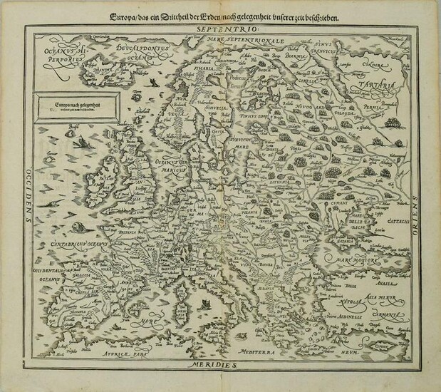
1598 Munster / Petri Map of Europe -- Europa das ein
Title: 1598 Munster / Petri Map of Europe -- Europa das ein Drittheil der Erden nach gelegenheit unserer zeit beschrieben
Cartographer: Munster / Petri
Year/Place: 1598 c., Basel
Map Dimensions (in.): 12.2 X 14.3 in
Description: This is a very handsome woodblock map of Europe. It includes some real islands -- Iceland and a bit of Greenland -- the mythical Atlantic islands of Brasil and Demar west of Ireland are included as well. Details shown include topography, lakes, rivers, forests, and many major cities. Several sea monsters and ships fill the seas. This is Petri's revised map of Europe, replacing Munster's original version that had south oriented at the top of the map. German text on verso.
Reserve: $320.00
Shipping:
Domestic: Flat-rate of $22.00 to anywhere within the contiguous U.S.
International: Foreign shipping rates are determined by destination. International shipping may be subject to VAT.
Combined shipping: Please ask about combined shipping for multiple lots before bidding.
Location: This item ships from Ohio
Your purchase is protected:
Photos, descriptions, and estimates were prepared with the utmost care by a fully certified expert and appraiser. All items in this sale are guaranteed authentic.
In the rare event that the item did not conform to the lot description in the sale, Jasper52 specialists are here to help. Buyers may return the item for a full refund provided you notify Jasper52 within 5 days of receiving the item.
Condition Report: Very good. On laid paper. Slight soiling. Issued centerfold. Uncolored.
View it on
Sale price
Estimate
Time, Location
Auction House
Title: 1598 Munster / Petri Map of Europe -- Europa das ein Drittheil der Erden nach gelegenheit unserer zeit beschrieben
Cartographer: Munster / Petri
Year/Place: 1598 c., Basel
Map Dimensions (in.): 12.2 X 14.3 in
Description: This is a very handsome woodblock map of Europe. It includes some real islands -- Iceland and a bit of Greenland -- the mythical Atlantic islands of Brasil and Demar west of Ireland are included as well. Details shown include topography, lakes, rivers, forests, and many major cities. Several sea monsters and ships fill the seas. This is Petri's revised map of Europe, replacing Munster's original version that had south oriented at the top of the map. German text on verso.
Reserve: $320.00
Shipping:
Domestic: Flat-rate of $22.00 to anywhere within the contiguous U.S.
International: Foreign shipping rates are determined by destination. International shipping may be subject to VAT.
Combined shipping: Please ask about combined shipping for multiple lots before bidding.
Location: This item ships from Ohio
Your purchase is protected:
Photos, descriptions, and estimates were prepared with the utmost care by a fully certified expert and appraiser. All items in this sale are guaranteed authentic.
In the rare event that the item did not conform to the lot description in the sale, Jasper52 specialists are here to help. Buyers may return the item for a full refund provided you notify Jasper52 within 5 days of receiving the item.
Condition Report: Very good. On laid paper. Slight soiling. Issued centerfold. Uncolored.


