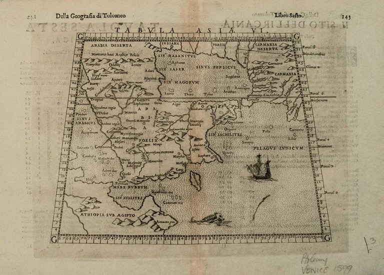
1598 Ruscelli Map of the Arabian Peninsula -- Tabula
Title/Content of Map: 1598 Ruscelli Map of the Arabian Peninsula -- Tabula Asiae VI
Date: 1598, VeniceCartographer: G Ruscelli
Size: 7.1 X 9.3 in.
This is a handsome map centered around the Arabian Peninsula and the Persian Gulf with Ethiopia and Somalia also shown in part.The Red Sea and Gulf of Adan fairly accurate.Details shown include topography, settlements, many rivers and islands, with many being imaginary. This example is the third state of the map, which was first published in 1561 and revised in 1574.This, the final 1598 edition which is re-engraved and revised to include a Sea Monster and Sailing Ship is much scarcer than its predecessors.
Reserve: $200.00
Shipping:
Domestic: Flat-rate of $14.00 to anywhere within the contiguous U.S.
International: Foreign shipping rates are determined by destination.
Combined shipping: Please ask about combined shipping for multiple lots before bidding.
Location: This item ships from Ohio
Your purchase is protected:
Photos, descriptions, and estimates were prepared with the utmost care by a fully certified expert and appraiser. All items in this sale are guaranteed authentic.
In the rare event that the item did not conform to the lot description in the sale, Jasper52 specialists are here to help. Buyers may return the item for a full refund provided you notify Jasper52 within 5 days of receiving the item.
Condition Report: Very good.Clear strike on watermarked laid paper. Slight discoloration in the issued centerfold.Italian text on verso.
View it on
Estimate
Time, Location
Auction House
Title/Content of Map: 1598 Ruscelli Map of the Arabian Peninsula -- Tabula Asiae VI
Date: 1598, VeniceCartographer: G Ruscelli
Size: 7.1 X 9.3 in.
This is a handsome map centered around the Arabian Peninsula and the Persian Gulf with Ethiopia and Somalia also shown in part.The Red Sea and Gulf of Adan fairly accurate.Details shown include topography, settlements, many rivers and islands, with many being imaginary. This example is the third state of the map, which was first published in 1561 and revised in 1574.This, the final 1598 edition which is re-engraved and revised to include a Sea Monster and Sailing Ship is much scarcer than its predecessors.
Reserve: $200.00
Shipping:
Domestic: Flat-rate of $14.00 to anywhere within the contiguous U.S.
International: Foreign shipping rates are determined by destination.
Combined shipping: Please ask about combined shipping for multiple lots before bidding.
Location: This item ships from Ohio
Your purchase is protected:
Photos, descriptions, and estimates were prepared with the utmost care by a fully certified expert and appraiser. All items in this sale are guaranteed authentic.
In the rare event that the item did not conform to the lot description in the sale, Jasper52 specialists are here to help. Buyers may return the item for a full refund provided you notify Jasper52 within 5 days of receiving the item.
Condition Report: Very good.Clear strike on watermarked laid paper. Slight discoloration in the issued centerfold.Italian text on verso.


