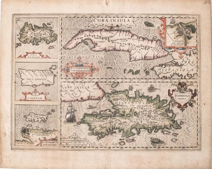
1613 Mercator/Hondius Map of Caribbean Islands -- Cuba
Title/Content of Map: 1613 Mercator/Hondius Map of Caribbean Islands -- Cuba Insula [on sheet with] Hispaniola Insula [and] Insula Iamaica [and] Ins. S. Ioannis [and] Is. Margareta cum Confiniis
Date: 1613, AmsterdamCartographer: Mercator/Hondius
Size: 13.8 x 19.5 in.
An attractive interesting collection of Caribbean maps on one sheet map including Cuba, Hispaniola, and smaller insets of Havana, Jamaica, Puerto Rico and Margarita, off the Venezuelan coast. Topographical details, especially along the coasts, and settlements are shown. The map is richly embellished with a variety of sea monsters, a flying fish, sailing ships and strapwork cartouches. Copper engraved.
Reserve: $400.00
Shipping:
Domestic: Flat-rate of $12.00 to anywhere within the contiguous U.S.
International: Foreign shipping rates are determined by destination.
Combined shipping: Please ask about combined shipping for multiple lots before bidding.
Location: This item ships from Ohio
Your purchase is protected:
Photos, descriptions, and estimates were prepared with the utmost care by a fully certified expert and appraiser. All items in this sale are guaranteed authentic.
In the rare event that the item did not conform to the lot description in the sale, Jasper52 specialists are here to help. Buyers may return the item for a full refund provided you notify Jasper52 within 5 days of receiving the item.
Condition Report: Fair. General toning throughout and some foxing. Few splits, some into the map, restored on verso. Good coloring. Mounted on slightly fragile paper board for framing, and margins cut to size.
View it on
Sale price
Estimate
Time, Location
Auction House
Title/Content of Map: 1613 Mercator/Hondius Map of Caribbean Islands -- Cuba Insula [on sheet with] Hispaniola Insula [and] Insula Iamaica [and] Ins. S. Ioannis [and] Is. Margareta cum Confiniis
Date: 1613, AmsterdamCartographer: Mercator/Hondius
Size: 13.8 x 19.5 in.
An attractive interesting collection of Caribbean maps on one sheet map including Cuba, Hispaniola, and smaller insets of Havana, Jamaica, Puerto Rico and Margarita, off the Venezuelan coast. Topographical details, especially along the coasts, and settlements are shown. The map is richly embellished with a variety of sea monsters, a flying fish, sailing ships and strapwork cartouches. Copper engraved.
Reserve: $400.00
Shipping:
Domestic: Flat-rate of $12.00 to anywhere within the contiguous U.S.
International: Foreign shipping rates are determined by destination.
Combined shipping: Please ask about combined shipping for multiple lots before bidding.
Location: This item ships from Ohio
Your purchase is protected:
Photos, descriptions, and estimates were prepared with the utmost care by a fully certified expert and appraiser. All items in this sale are guaranteed authentic.
In the rare event that the item did not conform to the lot description in the sale, Jasper52 specialists are here to help. Buyers may return the item for a full refund provided you notify Jasper52 within 5 days of receiving the item.
Condition Report: Fair. General toning throughout and some foxing. Few splits, some into the map, restored on verso. Good coloring. Mounted on slightly fragile paper board for framing, and margins cut to size.


![[Portraits]. "Gerardus Mercator (...) Iudocus Hondius (...)." Handcol. and gommé... [Portraits]. "Gerardus Mercator (...) Iudocus Hondius (...)." Handcol. and gommé...](https://gcp-la8-storage-cdn.lot-art.com/public/upl/39/Portraits-Gerardus-Mercator-Iudocus-Hondius-Handcol-and-gomme_662941d77ad1c-thumb-09569000_1713979864-662941d8175d4.jpg)


