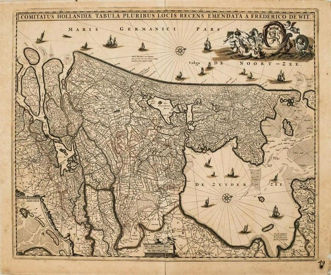
1680 de Wit Map of the Netherlands -- Comitatus
Title/Content of Map: 1680 de Wit Map of the Netherlands -- Comitatus Hollandiae Tabula Pluribus Locis Recens Emendata a Frederico de Wit
Date: 1680, Amsterdam
Cartographer: F de Wit
Size: 18.2 X 21.9 in.
This quite decorative map shows Utrecht and parts of Friesland and Brabant with their coasts -- today's Netherlands.much detail is offered including canals, roads, polders, marshes, and villages and major cities including Amsterdam. The West Frisian Islands are shown in an inset. Compass roses orient north to the right and a variety of sailing vessels fill the seas. A host of mermen pull a sea chariot with the Dutch coat of arms and a pair of surveyors decorate the scale cartouche at bottom.Visscher issued in contemporary period a very similar map.
Reserve: $360.00
Shipping:
Domestic: Flat-rate of $16.00 to anywhere within the contiguous U.S.
International: Foreign shipping rates are determined by destination.
Combined shipping: Please ask about combined shipping for multiple lots before bidding.
Location: This item ships from Ohio
Your purchase is protected:
Photos, descriptions, and estimates were prepared with the utmost care by a fully certified expert and appraiser. All items in this sale are guaranteed authentic.
In the rare event that the item did not conform to the lot description in the sale, Jasper52 specialists are here to help. Buyers may return the item for a full refund provided you notify Jasper52 within 5 days of receiving the item.
Condition Report: Very Good.Nice strike on laid paper.Very slight toning.Slight stainingand a few mostly marginal foxing spots.A few splits and chips in the margins.Issued centerfold.Hand colored.
View it on
Estimate
Time, Location
Auction House
Title/Content of Map: 1680 de Wit Map of the Netherlands -- Comitatus Hollandiae Tabula Pluribus Locis Recens Emendata a Frederico de Wit
Date: 1680, Amsterdam
Cartographer: F de Wit
Size: 18.2 X 21.9 in.
This quite decorative map shows Utrecht and parts of Friesland and Brabant with their coasts -- today's Netherlands.much detail is offered including canals, roads, polders, marshes, and villages and major cities including Amsterdam. The West Frisian Islands are shown in an inset. Compass roses orient north to the right and a variety of sailing vessels fill the seas. A host of mermen pull a sea chariot with the Dutch coat of arms and a pair of surveyors decorate the scale cartouche at bottom.Visscher issued in contemporary period a very similar map.
Reserve: $360.00
Shipping:
Domestic: Flat-rate of $16.00 to anywhere within the contiguous U.S.
International: Foreign shipping rates are determined by destination.
Combined shipping: Please ask about combined shipping for multiple lots before bidding.
Location: This item ships from Ohio
Your purchase is protected:
Photos, descriptions, and estimates were prepared with the utmost care by a fully certified expert and appraiser. All items in this sale are guaranteed authentic.
In the rare event that the item did not conform to the lot description in the sale, Jasper52 specialists are here to help. Buyers may return the item for a full refund provided you notify Jasper52 within 5 days of receiving the item.
Condition Report: Very Good.Nice strike on laid paper.Very slight toning.Slight stainingand a few mostly marginal foxing spots.A few splits and chips in the margins.Issued centerfold.Hand colored.


![[Netherlands]. "The United Provinces of the Netherlands with their Conquests... [Netherlands]. "The United Provinces of the Netherlands with their Conquests...](https://gcp-la8-storage-cdn.lot-art.com/public/upl/16/Netherlands-The-United-Provinces-of-the-Netherlands-with-their-Conquests_6629481e583a3-thumb-92249700_1713981470-6629481ee138f.jpg)


