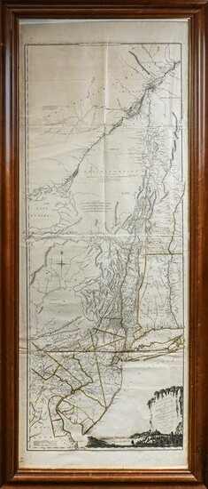
1775 Jefferys Map of NY, NJ & PA
1775 Thomas Jefferys "Map of the Provinces of New York and New Jersey, with part of Pensilvania", drawn by Capt Holland, engr 15 June, 1775, British Revolutionary War era map of the Northeastern US, 4 sheet, folds, creases, minor edge loss, 52 1/2" x 20 1/4" from the neat lines, plus margins, framed overall 63 1/2" x 27 1/2"
Condition Report: While we make our best effort to note any issues on items either in writing or by photograph, absence of a formal condition report does not imply that a piece is perfect, free from defects, or the effects of aging. Please review the photos carefully and consider them part of the description of a lot prior to bidding. Any condition statement is a courtesy to our buyers and should be considered our opinion and not a statement of fact or free from human error. Requests for additional information can be made by email or phone, and will be responded to on a first come first served basis.
View it on
Sale price
Estimate
Time, Location
Auction House
1775 Thomas Jefferys "Map of the Provinces of New York and New Jersey, with part of Pensilvania", drawn by Capt Holland, engr 15 June, 1775, British Revolutionary War era map of the Northeastern US, 4 sheet, folds, creases, minor edge loss, 52 1/2" x 20 1/4" from the neat lines, plus margins, framed overall 63 1/2" x 27 1/2"
Condition Report: While we make our best effort to note any issues on items either in writing or by photograph, absence of a formal condition report does not imply that a piece is perfect, free from defects, or the effects of aging. Please review the photos carefully and consider them part of the description of a lot prior to bidding. Any condition statement is a courtesy to our buyers and should be considered our opinion and not a statement of fact or free from human error. Requests for additional information can be made by email or phone, and will be responded to on a first come first served basis.


