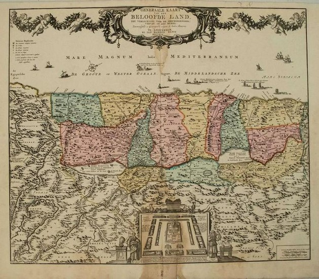
1792 Elwe Map of the Holy Land -- Generaale Kaart van
Title/Content of Map: 1792 Elwe Map of the Holy Land -- Generaale Kaart van het Beloofde Land tot Verlichting voor de Geschiedenisse; Vervat in des Bybel
Date: 1792, AmsterdamCartographer: J Elwe
Size: 19.5 X 23.3 in.
This is a superb double-page map of the Holy Land.West is oriented to the top of the map.The map is divided into the twelve tribes of Israel. Several roads are depicted and the route of the Children of Israel through the desert.At the bottom center is an engraving of the Tabernacle surrounded by the twelve tribes and flanked by Moses and Aaron. The Mediterranean is filled with various types of ships and boats, including a depiction of Jonah and the whale.The map is spanned by a large title cartouche draped in a garland held aloft by six cherubs.The map is based on de Wit's version and is from Elwe's monumental 'Atlas'.
Reserve: $260.00
Shipping:
Domestic: Flat-rate of $16.00 to anywhere within the contiguous U.S.
International: Foreign shipping rates are determined by destination.
Combined shipping: Please ask about combined shipping for multiple lots before bidding.
Location: This item ships from Ohio
Your purchase is protected:
Photos, descriptions, and estimates were prepared with the utmost care by a fully certified expert and appraiser. All items in this sale are guaranteed authentic.
In the rare event that the item did not conform to the lot description in the sale, Jasper52 specialists are here to help. Buyers may return the item for a full refund provided you notify Jasper52 within 5 days of receiving the item.
Condition Report: Good-fair.Nice strike on laid paper.Damp staining in lower and upper portions of issed centerfold.A split in lower portion closed on verso.Superb original hand color.
View it on
Estimate
Time, Location
Auction House
Title/Content of Map: 1792 Elwe Map of the Holy Land -- Generaale Kaart van het Beloofde Land tot Verlichting voor de Geschiedenisse; Vervat in des Bybel
Date: 1792, AmsterdamCartographer: J Elwe
Size: 19.5 X 23.3 in.
This is a superb double-page map of the Holy Land.West is oriented to the top of the map.The map is divided into the twelve tribes of Israel. Several roads are depicted and the route of the Children of Israel through the desert.At the bottom center is an engraving of the Tabernacle surrounded by the twelve tribes and flanked by Moses and Aaron. The Mediterranean is filled with various types of ships and boats, including a depiction of Jonah and the whale.The map is spanned by a large title cartouche draped in a garland held aloft by six cherubs.The map is based on de Wit's version and is from Elwe's monumental 'Atlas'.
Reserve: $260.00
Shipping:
Domestic: Flat-rate of $16.00 to anywhere within the contiguous U.S.
International: Foreign shipping rates are determined by destination.
Combined shipping: Please ask about combined shipping for multiple lots before bidding.
Location: This item ships from Ohio
Your purchase is protected:
Photos, descriptions, and estimates were prepared with the utmost care by a fully certified expert and appraiser. All items in this sale are guaranteed authentic.
In the rare event that the item did not conform to the lot description in the sale, Jasper52 specialists are here to help. Buyers may return the item for a full refund provided you notify Jasper52 within 5 days of receiving the item.
Condition Report: Good-fair.Nice strike on laid paper.Damp staining in lower and upper portions of issed centerfold.A split in lower portion closed on verso.Superb original hand color.


