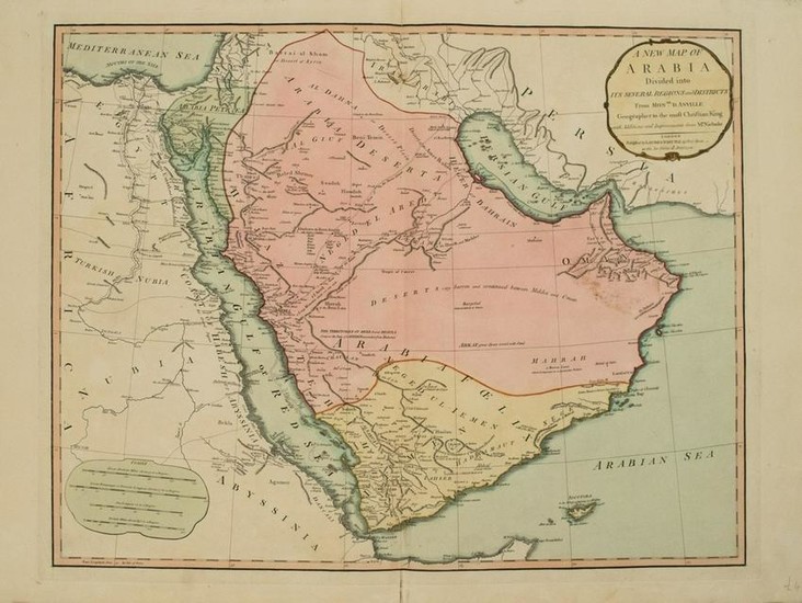
1794 Anville Map of the Arabian Peninsula and Red Sea
Title: 1794 Anville Map of the Arabian Peninsula and Red Sea -- A New Map of Arabia Divided into its Several Regions and Districts from Mons. D'Anville…
Date: 1794, London
Medium: J d'Anville / Larie and Whittle
Size: 24.5 X 19.4 in.
Additional Information: This a highly detailed larger map of the Arabian Peninsula and extending to show the northeastern part of Africa from Egypt down to Somalia.Both the Red Sea and the Persian Gulf are shown in their entirity.Details shown include topography, towns, cities, rivers, tribes, caravan routes with its stops, areas of ruins, and deserts of course.The map is filled with notes including locations of walled cities, water sources, terrain, and ruins.Political subdivisions are color-coded.Published by Laurie and Whittle.
Reserve: $260.00
Shipping:
Domestic: Flat-rate of $14.00 to anywhere within the contiguous U.S.
International: Foreign shipping rates are determined by destination.
Combined shipping: Please ask about combined shipping for multiple lots before bidding.
Location: This item ships from Ohio.
Your purchase is protected:
Photos, descriptions, and estimates were prepared with the utmost care by a fully certified expert and appraiser. All items in this sale are guaranteed authentic.
In the rare event that the item did not conform to the lot description in the sale, Jasper52 specialists are here to help. Buyers may return the item for a full refund provided you notify Jasper52 within 5 days of receiving the item.
Condition Report: Very good.Nice strike and color.Issued centerfold with small split.
View it on
Estimate
Time, Location
Auction House
Title: 1794 Anville Map of the Arabian Peninsula and Red Sea -- A New Map of Arabia Divided into its Several Regions and Districts from Mons. D'Anville…
Date: 1794, London
Medium: J d'Anville / Larie and Whittle
Size: 24.5 X 19.4 in.
Additional Information: This a highly detailed larger map of the Arabian Peninsula and extending to show the northeastern part of Africa from Egypt down to Somalia.Both the Red Sea and the Persian Gulf are shown in their entirity.Details shown include topography, towns, cities, rivers, tribes, caravan routes with its stops, areas of ruins, and deserts of course.The map is filled with notes including locations of walled cities, water sources, terrain, and ruins.Political subdivisions are color-coded.Published by Laurie and Whittle.
Reserve: $260.00
Shipping:
Domestic: Flat-rate of $14.00 to anywhere within the contiguous U.S.
International: Foreign shipping rates are determined by destination.
Combined shipping: Please ask about combined shipping for multiple lots before bidding.
Location: This item ships from Ohio.
Your purchase is protected:
Photos, descriptions, and estimates were prepared with the utmost care by a fully certified expert and appraiser. All items in this sale are guaranteed authentic.
In the rare event that the item did not conform to the lot description in the sale, Jasper52 specialists are here to help. Buyers may return the item for a full refund provided you notify Jasper52 within 5 days of receiving the item.
Condition Report: Very good.Nice strike and color.Issued centerfold with small split.


