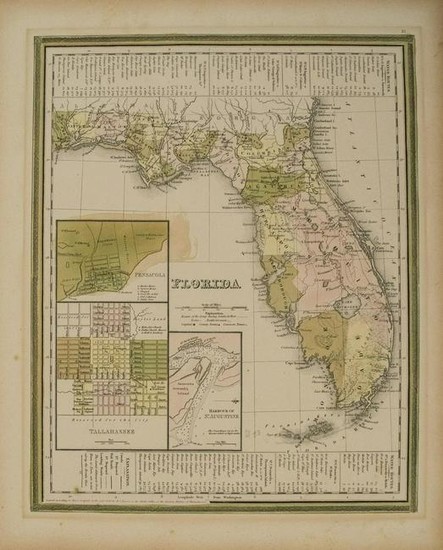
1839 Tanner Map of Florida -- Florida
Title/Content of Map: 1839 Tanner Map of Florida -- Florida
Date: 1839, Philadelphia
Cartographer: H Tanner
Size: 14.2 X 11.2 in
This is an attractive map of Florida. There are references to forts, battlefields, and routes used by the Army during the Seminole War. The three inset maps are Pensacola, Tallahassee, and Harbour of St. Augustine. The map reflects the configuration of counties in 1838 with the recent organization of Calhoun County.Water routes from St. Augustine and Pensacola to various ports are described in tables above and below the map.Tampa, St. Petersburg, Miami, Orlando and other currently large cities do not appear on this map.Details include topography, rivers, lakes, roads, early railroads in the north, towns and cities, Indian tribes, canals, forts, etc.
Reserve: $260.00
Shipping:
Domestic: Flat-rate of $14.00 to anywhere within the contiguous U.S.
International: Foreign shipping rates are determined by destination.
Combined shipping: Please ask about combined shipping for multiple lots before bidding.
Location: This item ships from Ohio
Your purchase is protected:
Photos, descriptions, and estimates were prepared with the utmost care by a fully certified expert and appraiser. All items in this sale are guaranteed authentic.
In the rare event that the item did not conform to the lot description in the sale, Jasper52 specialists are here to help. Buyers may return the item for a full refund provided you notify Jasper52 within 5 days of receiving the item.
Condition Report: Good.Marginal toning under previous matting.Small soil spot.Hand color.
View it on
Estimate
Time, Location
Auction House
Title/Content of Map: 1839 Tanner Map of Florida -- Florida
Date: 1839, Philadelphia
Cartographer: H Tanner
Size: 14.2 X 11.2 in
This is an attractive map of Florida. There are references to forts, battlefields, and routes used by the Army during the Seminole War. The three inset maps are Pensacola, Tallahassee, and Harbour of St. Augustine. The map reflects the configuration of counties in 1838 with the recent organization of Calhoun County.Water routes from St. Augustine and Pensacola to various ports are described in tables above and below the map.Tampa, St. Petersburg, Miami, Orlando and other currently large cities do not appear on this map.Details include topography, rivers, lakes, roads, early railroads in the north, towns and cities, Indian tribes, canals, forts, etc.
Reserve: $260.00
Shipping:
Domestic: Flat-rate of $14.00 to anywhere within the contiguous U.S.
International: Foreign shipping rates are determined by destination.
Combined shipping: Please ask about combined shipping for multiple lots before bidding.
Location: This item ships from Ohio
Your purchase is protected:
Photos, descriptions, and estimates were prepared with the utmost care by a fully certified expert and appraiser. All items in this sale are guaranteed authentic.
In the rare event that the item did not conform to the lot description in the sale, Jasper52 specialists are here to help. Buyers may return the item for a full refund provided you notify Jasper52 within 5 days of receiving the item.
Condition Report: Good.Marginal toning under previous matting.Small soil spot.Hand color.


