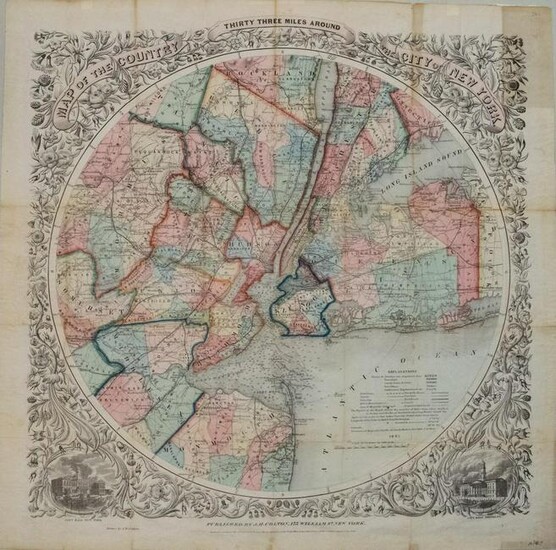
1846 Colton Map of the Area 33 Miles Around New York
Title/Content of Map: 1846 Colton Map of the Area 33 Miles Around New York City -- Map of the Country Thirty Three Miles Around The City of New York
Cartographer: G Colton
Year/Place: 1846, New York
Size: 22 X 22 in.
This is a somewhat scarce and splendid larger circular map of New York City, part of Long Island, and part of New Jersey. The map is designed to show the transportation network of roads, canals and railways, with distances and terminals noted. It also depicts the telegraph lines and mills or manufactories. Harbor is marked with soundings and navigational hazards. Beautifully colored and surrounded by a wide floral border with vignettes of the City Halls of both New York City and Brooklyn at the bottom two corners.
Reserve: $1,100.00
Shipping:
Domestic: Flat-rate of $24.00 to anywhere within the contiguous U.S.
International: Foreign shipping rates are determined by destination.
Combined shipping: Please ask about combined shipping for multiple lots before bidding.
Location: This item ships from Ohio
Your purchase is protected:
Photos, descriptions, and estimates were prepared with the utmost care by a fully certified expert and appraiser. All items in this sale are guaranteed authentic.
In the rare event that the item did not conform to the lot description in the sale, Jasper52 specialists are here to help. Buyers may return the item for a full refund provided you notify Jasper52 within 5 days of receiving the item.
Condition Report: Very Good. On thinner paper with issued folds. A few foxing spots and age toning, primarily in the folds. Nicely colored.
View it on
Estimate
Time, Location
Auction House
Title/Content of Map: 1846 Colton Map of the Area 33 Miles Around New York City -- Map of the Country Thirty Three Miles Around The City of New York
Cartographer: G Colton
Year/Place: 1846, New York
Size: 22 X 22 in.
This is a somewhat scarce and splendid larger circular map of New York City, part of Long Island, and part of New Jersey. The map is designed to show the transportation network of roads, canals and railways, with distances and terminals noted. It also depicts the telegraph lines and mills or manufactories. Harbor is marked with soundings and navigational hazards. Beautifully colored and surrounded by a wide floral border with vignettes of the City Halls of both New York City and Brooklyn at the bottom two corners.
Reserve: $1,100.00
Shipping:
Domestic: Flat-rate of $24.00 to anywhere within the contiguous U.S.
International: Foreign shipping rates are determined by destination.
Combined shipping: Please ask about combined shipping for multiple lots before bidding.
Location: This item ships from Ohio
Your purchase is protected:
Photos, descriptions, and estimates were prepared with the utmost care by a fully certified expert and appraiser. All items in this sale are guaranteed authentic.
In the rare event that the item did not conform to the lot description in the sale, Jasper52 specialists are here to help. Buyers may return the item for a full refund provided you notify Jasper52 within 5 days of receiving the item.
Condition Report: Very Good. On thinner paper with issued folds. A few foxing spots and age toning, primarily in the folds. Nicely colored.


