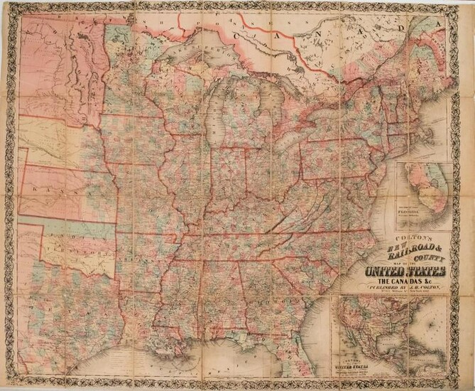
1862 Colton Map of the United States -- Colton's New
Title/Content of Map: 1862 Colton Map of the United States -- Colton's New Railroad & County Map of the United States the Canadas &c.
Cartographer: J Colton
Year/Place: 1862, New York
Size: 33.1 X 39 in.
This is a rare very large Civil War era folding map showing the eastern half of the United States to parts of Texas to Dakotahs, issued in 1862 (on map) but keeping portions of the 1861 issue in place. There is an extensive network of railroads displaying both existing and proposed routes and mail routes are shown as well. Plenty of other details are offered including topography, rivers, lakes, roads, steamship routes, ship routes, forts, cities, towns, etc. The map shows the color-coded counties. At right are two insets showing portions of Florida and North America except for much of Canada. The inset of North America shows the proposed Central and Union Pacific Railroads and some unusual western territorial borders, including the large New Mexico and Washigton, and an early appearance of Colorado. An owner's name is handwritten on verso.
Reserve: $700.00
Shipping:
Domestic: Flat-rate of $19.00 to anywhere within the contiguous U.S.
International: Foreign shipping rates are determined by destination.
Combined shipping: Please ask about combined shipping for multiple lots before bidding.
Location: This item ships from Ohio
Your purchase is protected:
Photos, descriptions, and estimates were prepared with the utmost care by a fully certified expert and appraiser. All items in this sale are guaranteed authentic.
In the rare event that the item did not conform to the lot description in the sale, Jasper52 specialists are here to help. Buyers may return the item for a full refund provided you notify Jasper52 within 5 days of receiving the item.
Condition Report: Good to fair. Nice strike. Some toning. Slight foxing, more noticeable on verso. Linen backed. Splits at issued folds, closed on verso. All folds have thicker tape on verso, so it is difficult to fold the map into closed case position. A few small voids at fold corners. Previously framed. Hand-colored.
View it on
Sale price
Estimate
Time, Location
Auction House
Title/Content of Map: 1862 Colton Map of the United States -- Colton's New Railroad & County Map of the United States the Canadas &c.
Cartographer: J Colton
Year/Place: 1862, New York
Size: 33.1 X 39 in.
This is a rare very large Civil War era folding map showing the eastern half of the United States to parts of Texas to Dakotahs, issued in 1862 (on map) but keeping portions of the 1861 issue in place. There is an extensive network of railroads displaying both existing and proposed routes and mail routes are shown as well. Plenty of other details are offered including topography, rivers, lakes, roads, steamship routes, ship routes, forts, cities, towns, etc. The map shows the color-coded counties. At right are two insets showing portions of Florida and North America except for much of Canada. The inset of North America shows the proposed Central and Union Pacific Railroads and some unusual western territorial borders, including the large New Mexico and Washigton, and an early appearance of Colorado. An owner's name is handwritten on verso.
Reserve: $700.00
Shipping:
Domestic: Flat-rate of $19.00 to anywhere within the contiguous U.S.
International: Foreign shipping rates are determined by destination.
Combined shipping: Please ask about combined shipping for multiple lots before bidding.
Location: This item ships from Ohio
Your purchase is protected:
Photos, descriptions, and estimates were prepared with the utmost care by a fully certified expert and appraiser. All items in this sale are guaranteed authentic.
In the rare event that the item did not conform to the lot description in the sale, Jasper52 specialists are here to help. Buyers may return the item for a full refund provided you notify Jasper52 within 5 days of receiving the item.
Condition Report: Good to fair. Nice strike. Some toning. Slight foxing, more noticeable on verso. Linen backed. Splits at issued folds, closed on verso. All folds have thicker tape on verso, so it is difficult to fold the map into closed case position. A few small voids at fold corners. Previously framed. Hand-colored.


