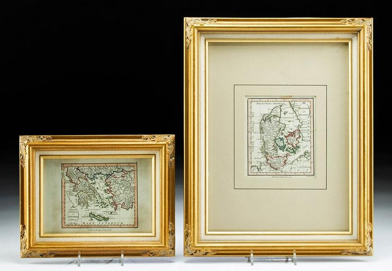
2 Framed 18th C. Faden Maps - Greece & Denmark
**Originally Listed At $200**
Cartographer: William Faden (British, 1749-1836). Engraver: William Palmer (British, 1735-1812). "Graecie Antiquae et Aegaei Maris Tabula" Published by William Faden January 1st 1793. AND "Denmark and Holstein" Published by William Faden January 1st 1798. A beautiful pair of antique maps published by British mapmaker William Faden and engraved by William Palmer. Both maps have been hand colored and are set in attractive matching frames. Size of Denmark & Holstein map: 5" L x 4.3" W (12.7 cm x 10.9 cm) Size of frame: 14.5" L x 11.5" W (36.8 cm x 29.2 cm)
William Faden was a respected mapmaker in London from the late 18th to the early 19th centuries. According to Barry Lawrence Ruderman, "Faden's star rose during the American Revolution, when he produced popular maps and atlases focused on the American colonies and the battles that raged within them. In 1783, just as the war ended, Faden inherited his father's estate, allowing him to fully control his business and expand it; in the same year he gained the title 'Geographer in Ordinary to his Majesty.' / Faden also commanded a large stock of British county maps, which made him attractive as a partner to the Ordnance Survey; he published the first Ordnance map in 1801, a map of Kent. The Admiralty also admired his work and acquired some of his plates which were re-issued as official naval charts. / Faden was renowned for his ingenuity as well as his business acumen. In 1796 he was awarded a gold medal by the Society of Arts. With his brother-in-law, the astronomer and painter John Russell, he created the first extant lunar globe."
Provenance: private J. P. collection, Rye, Colorado, USA; ex Bill Buffinger collection, Hollywood, California, USA
All items legal to buy/sell under U.S. Statute covering cultural patrimony Code 2600, CHAPTER 14, and are guaranteed to be as described or your money back.
A Certificate of Authenticity will accompany all winning bids.
PLEASE NOTE: Due to recent increases of shipments being seized by Australian & German customs (even for items with pre-UNESCO provenance), we will no longer ship most antiquities and ancient Chinese art to Australia & Germany. For categories of items that are acceptable to ship to Australia or Germany, please contact us directly or work with your local customs brokerage firm.
Display stands not described as included/custom in the item description are for photography purposes only and will not be included with the item upon shipping.
#166205
Condition Report: Maps have not been examined outside the frames. Both appear to be very good with minor stains and toning commensurate with age. Frames are very good and have suspension hooks, so ready to display.
View it on
Estimate
Time, Location
Auction House
**Originally Listed At $200**
Cartographer: William Faden (British, 1749-1836). Engraver: William Palmer (British, 1735-1812). "Graecie Antiquae et Aegaei Maris Tabula" Published by William Faden January 1st 1793. AND "Denmark and Holstein" Published by William Faden January 1st 1798. A beautiful pair of antique maps published by British mapmaker William Faden and engraved by William Palmer. Both maps have been hand colored and are set in attractive matching frames. Size of Denmark & Holstein map: 5" L x 4.3" W (12.7 cm x 10.9 cm) Size of frame: 14.5" L x 11.5" W (36.8 cm x 29.2 cm)
William Faden was a respected mapmaker in London from the late 18th to the early 19th centuries. According to Barry Lawrence Ruderman, "Faden's star rose during the American Revolution, when he produced popular maps and atlases focused on the American colonies and the battles that raged within them. In 1783, just as the war ended, Faden inherited his father's estate, allowing him to fully control his business and expand it; in the same year he gained the title 'Geographer in Ordinary to his Majesty.' / Faden also commanded a large stock of British county maps, which made him attractive as a partner to the Ordnance Survey; he published the first Ordnance map in 1801, a map of Kent. The Admiralty also admired his work and acquired some of his plates which were re-issued as official naval charts. / Faden was renowned for his ingenuity as well as his business acumen. In 1796 he was awarded a gold medal by the Society of Arts. With his brother-in-law, the astronomer and painter John Russell, he created the first extant lunar globe."
Provenance: private J. P. collection, Rye, Colorado, USA; ex Bill Buffinger collection, Hollywood, California, USA
All items legal to buy/sell under U.S. Statute covering cultural patrimony Code 2600, CHAPTER 14, and are guaranteed to be as described or your money back.
A Certificate of Authenticity will accompany all winning bids.
PLEASE NOTE: Due to recent increases of shipments being seized by Australian & German customs (even for items with pre-UNESCO provenance), we will no longer ship most antiquities and ancient Chinese art to Australia & Germany. For categories of items that are acceptable to ship to Australia or Germany, please contact us directly or work with your local customs brokerage firm.
Display stands not described as included/custom in the item description are for photography purposes only and will not be included with the item upon shipping.
#166205
Condition Report: Maps have not been examined outside the frames. Both appear to be very good with minor stains and toning commensurate with age. Frames are very good and have suspension hooks, so ready to display.

![[CARTE]. William FADEN. [CARTE]. William FADEN.](https://gcp-la8-storage-cdn.lot-art.com/public/upl/52/CARTE-William-FADEN_6621af9591b17-thumb-55980200_1713483670-6621af9688ac8.jpg)


