2 TN Maps, incl. Finley & Bradford
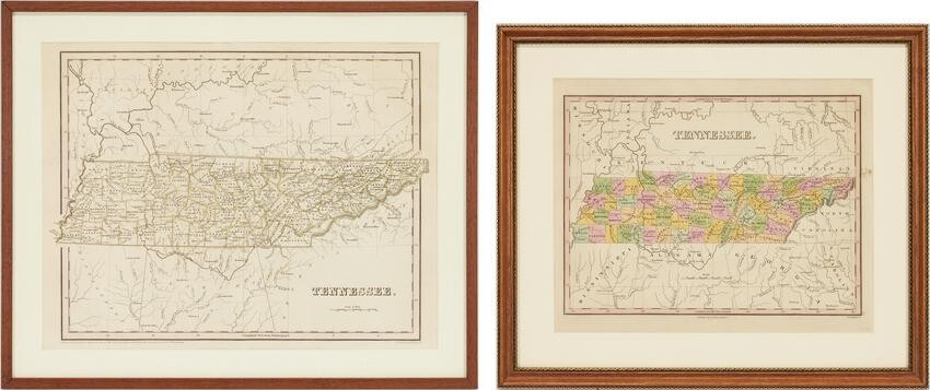
Two (2) Tennessee Maps. 1st item: TENNESSEE map, engraved by Young and Delleker, from A NEW GENERAL ATLAS, COMPRISING A COMPLETE SET OF MAPS drawn and published by Anthony Finley, Philadelphia, 1831. Copperplate engraving with hand-coloring map featuring Tennessee divided by county, depicting cities, towns, rivers, mountain ranges, and train tracks. Title, top center, scale of miles, lower center. Surrounded by scale notations and a line border. Housed and matted under plexiglass in a wooden frame. Image: 8 1/2" H x 11 1/2" W. Sight: 10" H x 12 3/8" W. Framed: 14 1/4" H x 16 5/8" W. 2nd item: TENNESSEE map, drawn by Thomas G. Bradford, engraved by George W. Boynton, from A COMPREHENSIVE ATLAS, GEOGRAPHICAL, HISTORICAL & COMMERICAL, published by American Stationers' Company, Boston, 1838. Copperplate engraving with hand-coloring of Kentucky and Tennessee depicting towns and roads, county lines, names of counties, rivers, and mountains. Title and scale of miles, lower left. Map surrounded by scale notations and triple line border. Image: 11 1/2" H x 14 3/4" W. Sight: 12" H x 15 1/2" W. Framed: 15 1/4" H x 18 3/4" W. Provenance: the estate of a Vanderbilt University professor, Nashville, Tennessee.
Condition Report: Both items in overall good condition with light toning. Not examined outside of frames. 1st item: 1/2" area of staining, top right outside of image.
View it on
Sale price
Estimate
Time, Location
Auction House
Two (2) Tennessee Maps. 1st item: TENNESSEE map, engraved by Young and Delleker, from A NEW GENERAL ATLAS, COMPRISING A COMPLETE SET OF MAPS drawn and published by Anthony Finley, Philadelphia, 1831. Copperplate engraving with hand-coloring map featuring Tennessee divided by county, depicting cities, towns, rivers, mountain ranges, and train tracks. Title, top center, scale of miles, lower center. Surrounded by scale notations and a line border. Housed and matted under plexiglass in a wooden frame. Image: 8 1/2" H x 11 1/2" W. Sight: 10" H x 12 3/8" W. Framed: 14 1/4" H x 16 5/8" W. 2nd item: TENNESSEE map, drawn by Thomas G. Bradford, engraved by George W. Boynton, from A COMPREHENSIVE ATLAS, GEOGRAPHICAL, HISTORICAL & COMMERICAL, published by American Stationers' Company, Boston, 1838. Copperplate engraving with hand-coloring of Kentucky and Tennessee depicting towns and roads, county lines, names of counties, rivers, and mountains. Title and scale of miles, lower left. Map surrounded by scale notations and triple line border. Image: 11 1/2" H x 14 3/4" W. Sight: 12" H x 15 1/2" W. Framed: 15 1/4" H x 18 3/4" W. Provenance: the estate of a Vanderbilt University professor, Nashville, Tennessee.
Condition Report: Both items in overall good condition with light toning. Not examined outside of frames. 1st item: 1/2" area of staining, top right outside of image.


