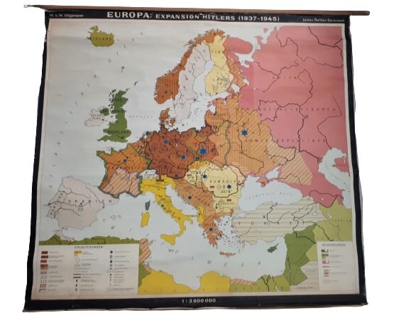
A huge map - Europe occupied by Hitler - markings of places of extermination of the Jews
EUROPA EXPANSION HITLERS (1937-1945 - A huge map depicting the Nazi-occupied Countries in 1937-1945 and the cities where concentration and extermination camps were established throughout Europe, as well as the places where entire Jewish communities were exterminated. Published by W. Hilgemaan, 1940s.
In the markings at the bottom left, there is, among other things, a sign of the Star of David in blue that characterizes the areas of the "Vernichtung der juden" - 'Extermination of the Jews'. A white pulley on a black square depicts the location of the Sitz der Einsatzgruppen - the Einsatzgruppen - the army camps of the SS 'Operation Formations', There is also a white pulley marked on a black circle - Kommandos der Einsatzgruppen - the 'commando' unit of the Nazi operations.
In the body of the map there are markings in different colors depicting the conquests of the Nazi army over the years, and the changes of borders after its conquests, and more.
Size: 135x144 cm. Thick paper attached to fabric. The map is attached to two long wooden poles at the top and bottom (cut off from the wooden at the top right). Good condition.
View it on
Reserve
Time, Location
Auction House
EUROPA EXPANSION HITLERS (1937-1945 - A huge map depicting the Nazi-occupied Countries in 1937-1945 and the cities where concentration and extermination camps were established throughout Europe, as well as the places where entire Jewish communities were exterminated. Published by W. Hilgemaan, 1940s.
In the markings at the bottom left, there is, among other things, a sign of the Star of David in blue that characterizes the areas of the "Vernichtung der juden" - 'Extermination of the Jews'. A white pulley on a black square depicts the location of the Sitz der Einsatzgruppen - the Einsatzgruppen - the army camps of the SS 'Operation Formations', There is also a white pulley marked on a black circle - Kommandos der Einsatzgruppen - the 'commando' unit of the Nazi operations.
In the body of the map there are markings in different colors depicting the conquests of the Nazi army over the years, and the changes of borders after its conquests, and more.
Size: 135x144 cm. Thick paper attached to fabric. The map is attached to two long wooden poles at the top and bottom (cut off from the wooden at the top right). Good condition.


