All the Countries in Jambudvipa
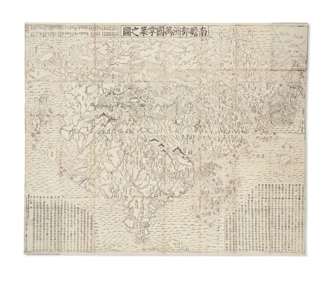
Nansenbushū bankoku shōka no zu [The Picture of all the Countries in Jambudvipa]. Japan, Edo period, 1710.
A rare example of an important early Japanese Buddhist map of the world, fusing traditional Buddhist belief with European cartography, which remained the prototype for all Japanese Buddhist world maps until the late 19th century. The map is based on the pilgrimage route of the famous Chinese priest Hsuang-Tsang (602-604) who travelled to India in the 7th century to collect holy Sanskrit writings. The first printed Japanese version of the Chinese narrative of the Si-yu-ki was issued in 1653, and was a major incentive for the publication of this map, which was used for Buddhist propaganda and education. The map was drawn up by Inda Rokashi, founder of the Kegonji Temple in Kyoto. The map centred on 'Jambu-Dvipa', the mythological heart of buddhist cosmography where Buddha was born in Northern India with the sacred lake of Anavatapta, and the four sacred rivers Ganges, Oxus, Indus, and Tarim flowing from it, the map extending from Ceylon to Siberia, and from Japan to the British Isles 'Country of the Western Woman', with Europe as a group of islands, Africa figured as a small island, and a land bridge connecting China with an unnamed continent to the East [America].
References: Simon Beal's translation of the Si-yu-ki, London: 1884. N. Muroga and K. Unno, Imago Mundi, vol. 16. 1962; H. Cortazzi, Isles of Gold, p.38; K. Unno, Cartography in Japan, 1994, pp.346-477.
Woodcut wall map of the world, partialy hand-coloring, ink printed on native paper, on fourteen sheets joined, 1175 x 1425 mm, folded down to 235 x 180 mm. Title in banner at upper border, text block panels with references to Buddhist writings to lower left and right corners, texts in Chinese and Japanese, seas with stylized waves, islands, rivers and mountains profusely named. Inner contour lines of some places hand-colored in purple. (Minor wear to folds including some short separations, scattered few wormholes, few spots.)Original blue paper covers with title label, a small horizontal slip of title is attached to the bottom of the front cover (loss of paper to the title slip, covers faded and worn).
Please note that this lot is subject to an import tariff. If the buyer instructs Christie’s to arrange shipping of the lot to a foreign address, the buyer will not be required to pay the import tariff. If the buyer instructs Christie’s to arrange shipping of the lot to a domestic address, if the buyer collects the property in person, or if the buyer arranges their own shipping (whether domestically or internationally), the buyer will be required to pay the import tariff. Please contact Post Sale Services on +1 212 636 2650 prior to bidding for more information.
View it on
Sale price
Estimate
Time, Location
Auction House
Nansenbushū bankoku shōka no zu [The Picture of all the Countries in Jambudvipa]. Japan, Edo period, 1710.
A rare example of an important early Japanese Buddhist map of the world, fusing traditional Buddhist belief with European cartography, which remained the prototype for all Japanese Buddhist world maps until the late 19th century. The map is based on the pilgrimage route of the famous Chinese priest Hsuang-Tsang (602-604) who travelled to India in the 7th century to collect holy Sanskrit writings. The first printed Japanese version of the Chinese narrative of the Si-yu-ki was issued in 1653, and was a major incentive for the publication of this map, which was used for Buddhist propaganda and education. The map was drawn up by Inda Rokashi, founder of the Kegonji Temple in Kyoto. The map centred on 'Jambu-Dvipa', the mythological heart of buddhist cosmography where Buddha was born in Northern India with the sacred lake of Anavatapta, and the four sacred rivers Ganges, Oxus, Indus, and Tarim flowing from it, the map extending from Ceylon to Siberia, and from Japan to the British Isles 'Country of the Western Woman', with Europe as a group of islands, Africa figured as a small island, and a land bridge connecting China with an unnamed continent to the East [America].
References: Simon Beal's translation of the Si-yu-ki, London: 1884. N. Muroga and K. Unno, Imago Mundi, vol. 16. 1962; H. Cortazzi, Isles of Gold, p.38; K. Unno, Cartography in Japan, 1994, pp.346-477.
Woodcut wall map of the world, partialy hand-coloring, ink printed on native paper, on fourteen sheets joined, 1175 x 1425 mm, folded down to 235 x 180 mm. Title in banner at upper border, text block panels with references to Buddhist writings to lower left and right corners, texts in Chinese and Japanese, seas with stylized waves, islands, rivers and mountains profusely named. Inner contour lines of some places hand-colored in purple. (Minor wear to folds including some short separations, scattered few wormholes, few spots.)Original blue paper covers with title label, a small horizontal slip of title is attached to the bottom of the front cover (loss of paper to the title slip, covers faded and worn).
Please note that this lot is subject to an import tariff. If the buyer instructs Christie’s to arrange shipping of the lot to a foreign address, the buyer will not be required to pay the import tariff. If the buyer instructs Christie’s to arrange shipping of the lot to a domestic address, if the buyer collects the property in person, or if the buyer arranges their own shipping (whether domestically or internationally), the buyer will be required to pay the import tariff. Please contact Post Sale Services on +1 212 636 2650 prior to bidding for more information.


