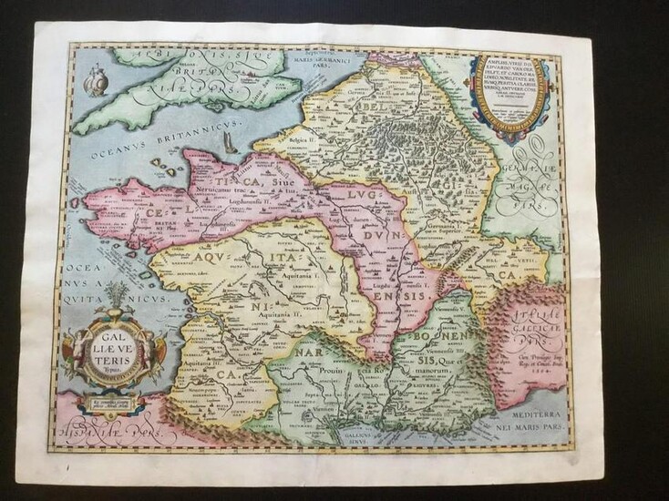
Ancient Gaul (France) based on ancient geographic
Title: Ancient Gaul (France) based on ancient geographic knowledge
Date/Period: 1570-1624
Materials: Hand colored, copperplate engraved.
Dimensions: 21 3/4 x 17 1/4”
From the THEATRUM ORBIS TERRARUM The worlds first true modern Atlas Published 1570-1624. Antwerp By Abraham Ortelius 15h7-1598 Royal Cosmographer to Philip II of Spain Approximate printed 3400. From Approximate survival 337 examples. 3.9%. MAP OF ANCIENT GAUL GAL: LIAE: VE:/ TERIS/TYPUS (FRANCE) based on multiple ancient authors, including Strabo, Ovid, Virgil and Caesar among others. Part of the Parergon edition of the Atlas, maps of the ancient world, created by Ortelius personally due to his interest in the ancient world, Based on contemporary ancient geographic knowledge.
Reserve: $550.00
Shipping:
Domestic: Free shipping to anywhere within the contiguous U.S.
International: Foreign shipping rates are determined by destination.
Combined shipping: Please ask about combined shipping for multiple lots before bidding.
Location: This item ships from New York
Your purchase is protected:
Photos, descriptions, and estimates were prepared with the utmost care by a fully certified expert and appraiser. All items in this sale are guaranteed authentic.
In the rare event that the item did not conform to the lot description in the sale, Jasper52 specialists are here to help. Buyers may return the item for a full refund provided you notify Jasper52 within 5 days of receiving the item.
Condition Report: Excellent condition
View it on
Estimate
Time, Location
Auction House
Title: Ancient Gaul (France) based on ancient geographic knowledge
Date/Period: 1570-1624
Materials: Hand colored, copperplate engraved.
Dimensions: 21 3/4 x 17 1/4”
From the THEATRUM ORBIS TERRARUM The worlds first true modern Atlas Published 1570-1624. Antwerp By Abraham Ortelius 15h7-1598 Royal Cosmographer to Philip II of Spain Approximate printed 3400. From Approximate survival 337 examples. 3.9%. MAP OF ANCIENT GAUL GAL: LIAE: VE:/ TERIS/TYPUS (FRANCE) based on multiple ancient authors, including Strabo, Ovid, Virgil and Caesar among others. Part of the Parergon edition of the Atlas, maps of the ancient world, created by Ortelius personally due to his interest in the ancient world, Based on contemporary ancient geographic knowledge.
Reserve: $550.00
Shipping:
Domestic: Free shipping to anywhere within the contiguous U.S.
International: Foreign shipping rates are determined by destination.
Combined shipping: Please ask about combined shipping for multiple lots before bidding.
Location: This item ships from New York
Your purchase is protected:
Photos, descriptions, and estimates were prepared with the utmost care by a fully certified expert and appraiser. All items in this sale are guaranteed authentic.
In the rare event that the item did not conform to the lot description in the sale, Jasper52 specialists are here to help. Buyers may return the item for a full refund provided you notify Jasper52 within 5 days of receiving the item.
Condition Report: Excellent condition


