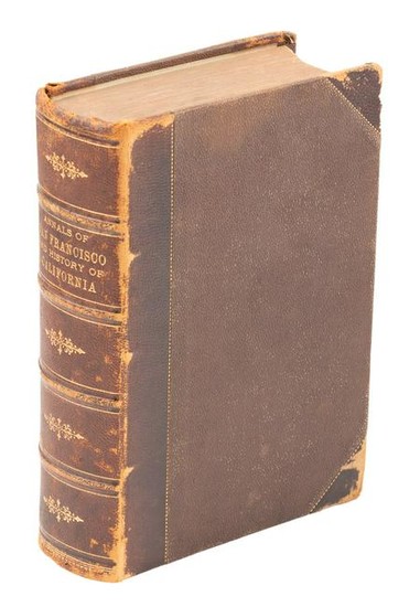
Annals of San Francisco, 1855
Heading:
Author: Soulé, Frank, John H. Gihon and James Nisbet
Title: The Annals of San Francisco; Containing a Summary of the History of the First Discovery, Settlement, Progress, and Present Condition of California...
Place Published: New York
Publisher:D. Appleton and Company
Date Published: 1855
Description:
824 pp. Illustrated with numerous wood engravings, 6 steel-engraved plates (including frontispiece); 2 maps (1 folding). (8vo) 22.3x14 cm (9x6"), brown three-quarters morocco with pebbled cloth boards, decorations and lettering in gilt, raised bands, top and bottom edges colored brown, pale green endpapers. First Edition.
The two maps are: "Map of San Francisco" (9.5x12.3 cm); and "General Map Showing the Countries Explored & Surveyed by the United States & Mexican Boundary Commission in the years 1850, 51, 52 & 53, under the direction of John R. Bartlett. U.S. Commissioner" (38.7x49 cm). This latter is a significant map of the American west and northern Mexico, with much detail in the regions newly wrested from the Mexican Republic (Kurutz 594; Cowan p.601; Graff 3901; Howes S769; Sabin 87268; Zamorano 80 #70).
Condition Report: Wear along sides of sunned spine, rubbing to corners of boards; front and rear hinges cracked, intermittent foxing and occasional dampstains, edges of textblock toned and foxed, front free endpaper missing, small tear on general map; very good.
View it on
Sale price
Estimate
Time, Location
Auction House
Heading:
Author: Soulé, Frank, John H. Gihon and James Nisbet
Title: The Annals of San Francisco; Containing a Summary of the History of the First Discovery, Settlement, Progress, and Present Condition of California...
Place Published: New York
Publisher:D. Appleton and Company
Date Published: 1855
Description:
824 pp. Illustrated with numerous wood engravings, 6 steel-engraved plates (including frontispiece); 2 maps (1 folding). (8vo) 22.3x14 cm (9x6"), brown three-quarters morocco with pebbled cloth boards, decorations and lettering in gilt, raised bands, top and bottom edges colored brown, pale green endpapers. First Edition.
The two maps are: "Map of San Francisco" (9.5x12.3 cm); and "General Map Showing the Countries Explored & Surveyed by the United States & Mexican Boundary Commission in the years 1850, 51, 52 & 53, under the direction of John R. Bartlett. U.S. Commissioner" (38.7x49 cm). This latter is a significant map of the American west and northern Mexico, with much detail in the regions newly wrested from the Mexican Republic (Kurutz 594; Cowan p.601; Graff 3901; Howes S769; Sabin 87268; Zamorano 80 #70).
Condition Report: Wear along sides of sunned spine, rubbing to corners of boards; front and rear hinges cracked, intermittent foxing and occasional dampstains, edges of textblock toned and foxed, front free endpaper missing, small tear on general map; very good.


