British, European, and Oriental Maps, Lot of Five
British, European, and Oriental Maps, Lot of Five
Five maps, including:
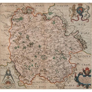
English, ca. 1637. Christophorus Saxton descripsit (English, 1540-1610), W. Hole sculp (English, 16th century-1624). Frugiferi ac ameni Herefordiae Comitatus qui olim pars suit Silurum delineatio, identified in cartouche l.r. A map of Herefordshire with a coat of arms u.r. and protractor symbol inscribed with cartographer and engraver names l.l. Printed text visible on back of including information about Herefordshire, 470 u.l., and about Silvres, 467 u.r. Hand colored and framed. 12.25 x 15.75 in. (sight), 13.75 x 17.25 in. (frame).
Flemish, 17th century. After Abraham Ortelius (Flemish, 1527-1598). India Orient, u.l. A miniature map of South East Asia spanning from Persia east to America and from New Guinea north to America. Hand colored and framed. 3.5 x 5 in. (sight), 11.75 x 13.5 in. (frame).
17th-18th century. The Deanary of Glocester, l.l. Road map of areas of Brocknor, Longhope, Glocester, Monmouth, and Micheldean with brief historical inscriptions and travel tips included below area names including The Forest of Dean, Micheldean, and Faringdon. Hand colored and framed. 7 x 5 in. (sight), 12.5 x 10.5 in. (frame).
English, ca. 1718. Thomas Gardner (English). The Road from Glocester to Montgomey [sic] North Wales. Title and artist identified with inscriptions within cartouche, including Humbly Inscrib'd [sic] to the Honourable George Caswal, Esq., u.c., 71 l.r. Road map of areas of Glocester, Hereford, Radnor, and Schrop. Matted and framed. 7.25 x 11 in. (sight), 12 x 16 in. (frame).
German, ca. 1862. Adolf Stieler (German, 1775-1836), Politische Übersicht von Europa. Titled u.l., Gez. v. H. Berghaus. l.l., Stieler's Schul Atlas No 6. u.r., Schrift gest. v. Poppey, Terrain v. Stichart l.r. Hand colored and framed. 9 x 11 in. (sight), 16.75 x 20.5 in. (frame).
Condition Report: Not examined out of frame. Some discoloration. Tear on upper right corner of Herefordshire map. Central vertical crease and spot of foxing on lower right border of Herefordshire map. Central vertical crease and dark spots on The Road from Glocester to Montgomey [sic] North Wales.
View it on
Sale price
Estimate
Time, Location
Auction House
British, European, and Oriental Maps, Lot of Five
Five maps, including:
English, ca. 1637. Christophorus Saxton descripsit (English, 1540-1610), W. Hole sculp (English, 16th century-1624). Frugiferi ac ameni Herefordiae Comitatus qui olim pars suit Silurum delineatio, identified in cartouche l.r. A map of Herefordshire with a coat of arms u.r. and protractor symbol inscribed with cartographer and engraver names l.l. Printed text visible on back of including information about Herefordshire, 470 u.l., and about Silvres, 467 u.r. Hand colored and framed. 12.25 x 15.75 in. (sight), 13.75 x 17.25 in. (frame).
Flemish, 17th century. After Abraham Ortelius (Flemish, 1527-1598). India Orient, u.l. A miniature map of South East Asia spanning from Persia east to America and from New Guinea north to America. Hand colored and framed. 3.5 x 5 in. (sight), 11.75 x 13.5 in. (frame).
17th-18th century. The Deanary of Glocester, l.l. Road map of areas of Brocknor, Longhope, Glocester, Monmouth, and Micheldean with brief historical inscriptions and travel tips included below area names including The Forest of Dean, Micheldean, and Faringdon. Hand colored and framed. 7 x 5 in. (sight), 12.5 x 10.5 in. (frame).
English, ca. 1718. Thomas Gardner (English). The Road from Glocester to Montgomey [sic] North Wales. Title and artist identified with inscriptions within cartouche, including Humbly Inscrib'd [sic] to the Honourable George Caswal, Esq., u.c., 71 l.r. Road map of areas of Glocester, Hereford, Radnor, and Schrop. Matted and framed. 7.25 x 11 in. (sight), 12 x 16 in. (frame).
German, ca. 1862. Adolf Stieler (German, 1775-1836), Politische Übersicht von Europa. Titled u.l., Gez. v. H. Berghaus. l.l., Stieler's Schul Atlas No 6. u.r., Schrift gest. v. Poppey, Terrain v. Stichart l.r. Hand colored and framed. 9 x 11 in. (sight), 16.75 x 20.5 in. (frame).
Condition Report: Not examined out of frame. Some discoloration. Tear on upper right corner of Herefordshire map. Central vertical crease and spot of foxing on lower right border of Herefordshire map. Central vertical crease and dark spots on The Road from Glocester to Montgomey [sic] North Wales.


