Brué
Heading:
Author: Brué, Adrien Hubert
Title: Atlas Universel de Géographie Physique, Politique et Historique. Ancienne et Moderne...
Place Published: Paris
Publisher:Chez l'Auteur
Date Published: 1822-[1827]
Description:
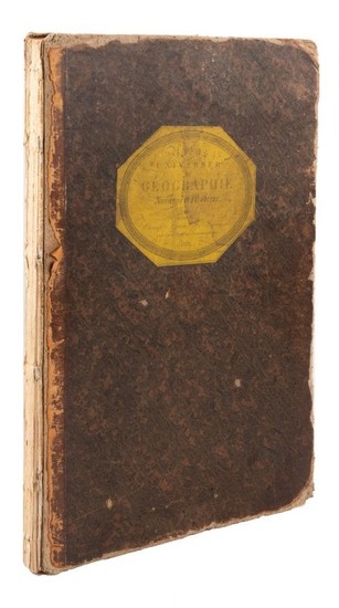
With 35 double-page copper-engraved plates hand-colored in outline (numbered 1-36, with a large fold-out France taking up two numbers); engraved title-page, list of plates, dedication-page, and leaf of letterpress. (Folio) 54x36 cm (21¼x14¼"), original quarter morocco & mottled boards, paper cover label.
Series of finely engraved maps, including the ancient world at various times, the European nations, Asia, Africa, etc. There are seven maps relating to the Americas, including "Carte de l'Amerique Septentrionale," dated 1825, with Ft. Astoria at the mouth of the Columbia, and Territoire Oregon, infringing on present-day British Columbia, plus the Sacramento and San Joaquin rivers, etc; "Carte Generale des Etats-Unis..." dated 1825, with the label Territoire Oregon well into the Missouri Valley; plus the Antilles, South American, the two World maps, and Oceanie. The list of maps calls for two maps of France, east and west, but a larger folding map of all of France has been substituted for them, as issued (this is splitting at centerfold). Each map bears the small blindstamp, "Carte Encyprotiph Propriete de l'Auteur." Wheat Transmississippi 361. Phillips Atlases 758 (citing 1834 edition).
Condition Report: Covers worn, edges well so, spine perished, covers detached or nearly so; minor internal aging, a few light marginal stains; very good overall.
View it on
Estimate
Time, Location
Auction House
Heading:
Author: Brué, Adrien Hubert
Title: Atlas Universel de Géographie Physique, Politique et Historique. Ancienne et Moderne...
Place Published: Paris
Publisher:Chez l'Auteur
Date Published: 1822-[1827]
Description:
With 35 double-page copper-engraved plates hand-colored in outline (numbered 1-36, with a large fold-out France taking up two numbers); engraved title-page, list of plates, dedication-page, and leaf of letterpress. (Folio) 54x36 cm (21¼x14¼"), original quarter morocco & mottled boards, paper cover label.
Series of finely engraved maps, including the ancient world at various times, the European nations, Asia, Africa, etc. There are seven maps relating to the Americas, including "Carte de l'Amerique Septentrionale," dated 1825, with Ft. Astoria at the mouth of the Columbia, and Territoire Oregon, infringing on present-day British Columbia, plus the Sacramento and San Joaquin rivers, etc; "Carte Generale des Etats-Unis..." dated 1825, with the label Territoire Oregon well into the Missouri Valley; plus the Antilles, South American, the two World maps, and Oceanie. The list of maps calls for two maps of France, east and west, but a larger folding map of all of France has been substituted for them, as issued (this is splitting at centerfold). Each map bears the small blindstamp, "Carte Encyprotiph Propriete de l'Auteur." Wheat Transmississippi 361. Phillips Atlases 758 (citing 1834 edition).
Condition Report: Covers worn, edges well so, spine perished, covers detached or nearly so; minor internal aging, a few light marginal stains; very good overall.


