China, Korea; Kircher, Athanasius. - Imperium Sinicum Quindecupartitum - 1661-1680
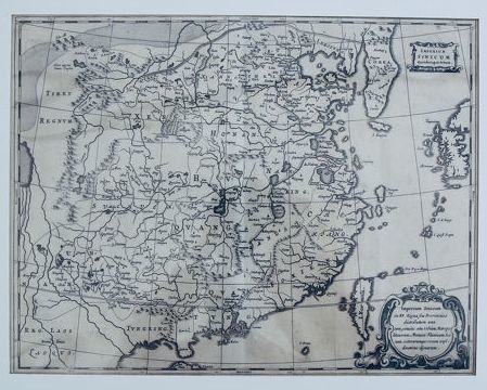
A detailed map of China with its topography, lakes and rivers, cities and the Great Wall. From Kirchers "China Monumentis, Qua Sacris Qua Profanis, Nec Non Variis Naturæ & Artis Spectaculis". This is an authentic, antique map of 17th century China, which includes much of Japan and Korea made by Athanasius Kircher. The map was published in 1667 in Amsterdam. This great map of China and Korea has hugely promoted the European knowledge of the area at the time it was produced. The map is based on work by the Jesuit, father Martino Martini, who collected numerous Chinese sources between 1643 and 1650. The map shows the correct locations of many cities and topographical characteristics. The trade route between Canton and Beijing is also featured and the Great Wall and the Gobi desert are both displayed graphically. This is the first copper engraving by Kircher, which was followed by a second version with several cartouches, but with the same title. Condition: good, wide margins, paper exhibits foxing especially at the edges and some brown spots. Please take a look at the photos for your own impression. Insured shipping.
[ translate ]View it on
Sale price
Estimate
Time, Location
Auction House
A detailed map of China with its topography, lakes and rivers, cities and the Great Wall. From Kirchers "China Monumentis, Qua Sacris Qua Profanis, Nec Non Variis Naturæ & Artis Spectaculis". This is an authentic, antique map of 17th century China, which includes much of Japan and Korea made by Athanasius Kircher. The map was published in 1667 in Amsterdam. This great map of China and Korea has hugely promoted the European knowledge of the area at the time it was produced. The map is based on work by the Jesuit, father Martino Martini, who collected numerous Chinese sources between 1643 and 1650. The map shows the correct locations of many cities and topographical characteristics. The trade route between Canton and Beijing is also featured and the Great Wall and the Gobi desert are both displayed graphically. This is the first copper engraving by Kircher, which was followed by a second version with several cartouches, but with the same title. Condition: good, wide margins, paper exhibits foxing especially at the edges and some brown spots. Please take a look at the photos for your own impression. Insured shipping.
[ translate ]


