Jan Jansson, Dutch, 1588-1664, Mappa Aestivarum Insularum, Alias Barmudas Dictarum, ad Ostia Mexicani Aestuary Jacetium...; a later hand-coloured engraved map of Bermuda, a reissue of the Hondius plate, from the Atlas Novus sive Theatrum Orbis...
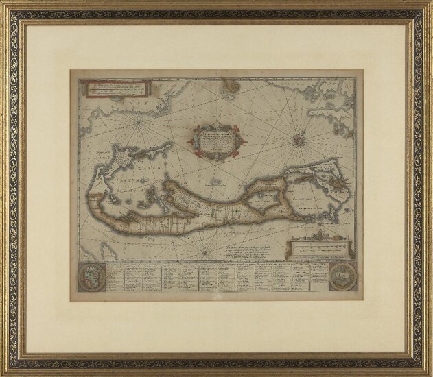
Jan Jansson, Dutch, 1588-1664, Mappa Aestivarum Insularum, Alias Barmudas Dictarum, ad Ostia Mexicani Aestuary Jacetium...; a later hand-coloured engraved map of Bermuda, a reissue of the Hondius plate, from the Atlas Novus sive Theatrum Orbis Terrarum, Amstelodami apud Joannem Janssonium Anno, Jansson reissued Hondius` plate with his imprint between 1647 and 1666, 49.5cm x 51.5cm Provenance: With Avril Noble, London, 8 December 1992 The Geoffrey and Fay Elliot collection. Note: Jansson and his brother-in-law, Henricus Hondius, published the Atlas Novus in 1637. Jansson inherited the Hondius publishing firm after Henricus’ death in 1657. This map is based on the famous survey by Richard Norwood of the Bermuda Company, also known as the Somers Isles Company, in 1618. The map shows the division into the original Tribes (a short-lived name for what became administrative parishes), named after major shareholders in the company. Also shown are the various landowners, with their names in a table below the map. There are many tiny houses shown on the map, locating settlements, as well as minute cannons marking the defensible points. The map is superimposed over a chart of the Atlantic with the coastlines of Britain, North America and Hispaniola showing the location of Bermuda.
Please refer to department for condition report
View it on
Sale price
Estimate
Reserve
Time, Location
Auction House
Jan Jansson, Dutch, 1588-1664, Mappa Aestivarum Insularum, Alias Barmudas Dictarum, ad Ostia Mexicani Aestuary Jacetium...; a later hand-coloured engraved map of Bermuda, a reissue of the Hondius plate, from the Atlas Novus sive Theatrum Orbis Terrarum, Amstelodami apud Joannem Janssonium Anno, Jansson reissued Hondius` plate with his imprint between 1647 and 1666, 49.5cm x 51.5cm Provenance: With Avril Noble, London, 8 December 1992 The Geoffrey and Fay Elliot collection. Note: Jansson and his brother-in-law, Henricus Hondius, published the Atlas Novus in 1637. Jansson inherited the Hondius publishing firm after Henricus’ death in 1657. This map is based on the famous survey by Richard Norwood of the Bermuda Company, also known as the Somers Isles Company, in 1618. The map shows the division into the original Tribes (a short-lived name for what became administrative parishes), named after major shareholders in the company. Also shown are the various landowners, with their names in a table below the map. There are many tiny houses shown on the map, locating settlements, as well as minute cannons marking the defensible points. The map is superimposed over a chart of the Atlantic with the coastlines of Britain, North America and Hispaniola showing the location of Bermuda.
Please refer to department for condition report


