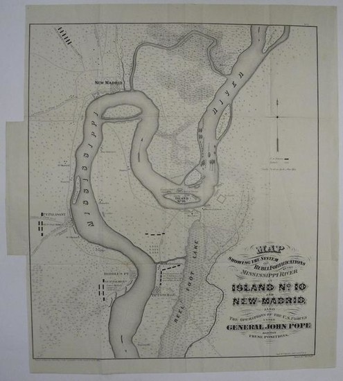
Map Showing the System of Rebel Fortifications of the
Title/Content of Map: Map Showing the System of Rebel Fortifications of the Mississippi River at Island No.10 And New-Madrid,
Date: 1866
Cartographer:
Publisher:
Size: 20.2Height - 17.25Width
also the operations of the U.S. forces under General John Pope against these positions. Captn. Wm. Hoelcke addt. a.de c. u.s.a. Report of Maj. Gen. John Pope to the Committee on the Conduct of the War. Stephenson (CW Maps in Lib. of Cong.) 2nd ed., #299.8. Large map of an area not usually covered in such detail: Mississippi river with islands, fortifications, gunboats, land based redoubts at Mrs. Donaldson('s) and Mrs. Isler('s); street plans and buildings of New Madrid, Pt. Pleasant, Riddle's Pt. and Tiptonville;Reel Foot Lake( and area to east drained by Reel Foot River shown as "Impassable for Troops on account of High Water"); various roads (including 2 which go through the lake), landowners' names (Dr. Hawkins, Dr. Martin's, Dan. Watson's, Harris, Darnell's, Lavelle's , Phillip's and Mrs Merryweather's {landing}); "Final Position of U.S. Forces, resulting in the capture of the Rebels." just north of Tiptonville; "Gen;. Palmer's Lower Battery2.24 Ppdrs. and 2.1 Ppdrs. parrots" south of Riddle's Point. Also shows the "Canal Excavated" by Gen. Pope's forces (and conscripted slaves) to circumvent the bend in the Mississippi defended by Island No. 10. Backed; lower half of left neat line trimmed and replaced; a couple of minor spots, else good example of the best Civil War map of this important Mississippi River battle. Island No. 10 Fortifications & Battle Map 1866
Reserve: $325.00
Shipping:
Domestic: Flat-rate of $18.00 to anywhere within the contiguous U.S.
International: Foreign shipping rates are determined by destination.
Combined shipping: Please ask about combined shipping for multiple lots before bidding.
Location: This item ships from Tennessee
Your purchase is protected:
Photos, descriptions, and estimates were prepared with the utmost care by a fully certified expert and appraiser. All items in this sale are guaranteed authentic.
In the rare event that the item did not conform to the lot description in the sale, Jasper52 specialists are here to help. Buyers may return the item for a full refund provided you notify Jasper52 within 5 days of receiving the item.
Condition Report: Good
View it on
Estimate
Time, Location
Auction House
Title/Content of Map: Map Showing the System of Rebel Fortifications of the Mississippi River at Island No.10 And New-Madrid,
Date: 1866
Cartographer:
Publisher:
Size: 20.2Height - 17.25Width
also the operations of the U.S. forces under General John Pope against these positions. Captn. Wm. Hoelcke addt. a.de c. u.s.a. Report of Maj. Gen. John Pope to the Committee on the Conduct of the War. Stephenson (CW Maps in Lib. of Cong.) 2nd ed., #299.8. Large map of an area not usually covered in such detail: Mississippi river with islands, fortifications, gunboats, land based redoubts at Mrs. Donaldson('s) and Mrs. Isler('s); street plans and buildings of New Madrid, Pt. Pleasant, Riddle's Pt. and Tiptonville;Reel Foot Lake( and area to east drained by Reel Foot River shown as "Impassable for Troops on account of High Water"); various roads (including 2 which go through the lake), landowners' names (Dr. Hawkins, Dr. Martin's, Dan. Watson's, Harris, Darnell's, Lavelle's , Phillip's and Mrs Merryweather's {landing}); "Final Position of U.S. Forces, resulting in the capture of the Rebels." just north of Tiptonville; "Gen;. Palmer's Lower Battery2.24 Ppdrs. and 2.1 Ppdrs. parrots" south of Riddle's Point. Also shows the "Canal Excavated" by Gen. Pope's forces (and conscripted slaves) to circumvent the bend in the Mississippi defended by Island No. 10. Backed; lower half of left neat line trimmed and replaced; a couple of minor spots, else good example of the best Civil War map of this important Mississippi River battle. Island No. 10 Fortifications & Battle Map 1866
Reserve: $325.00
Shipping:
Domestic: Flat-rate of $18.00 to anywhere within the contiguous U.S.
International: Foreign shipping rates are determined by destination.
Combined shipping: Please ask about combined shipping for multiple lots before bidding.
Location: This item ships from Tennessee
Your purchase is protected:
Photos, descriptions, and estimates were prepared with the utmost care by a fully certified expert and appraiser. All items in this sale are guaranteed authentic.
In the rare event that the item did not conform to the lot description in the sale, Jasper52 specialists are here to help. Buyers may return the item for a full refund provided you notify Jasper52 within 5 days of receiving the item.
Condition Report: Good


