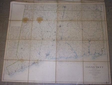
Map of Connecticut/ Prepared by the U.S. Geological
Title: Map of Connecticut/ Prepared by the U.S. Geological Survey in Co-Operation With the State of Connecticut/ U.S.G.S.. J.W. Powell, Director/ State Of Connecticut Commissioners: William H. Brewer, James H. Chapin, John W. Bacon/Contour Interval 100 Feet/Published by The Commision/ 1893/ Reprinted 1899.
Publication Date: 1899
Cartographer: POWELL, J. W.
Publisher: STATE OF CONNECTICUT COMMISSIONERS
Dimensions: 43 X 54.5
Additional Information: Extremely detailed with every building along every state road, street grids for towns and cities, topography (100 ft interval lines, hills mountains, swamps, lakes, ponds, rivers, reservoirs), roads, railroads, and much more minutiae.Two brown spots in upper left.Eastern half (8 of 16 panels) slightly darker than west.Dissected and laid on linen.Includes details of adjoining part of New York and Massachusetts.Important display/research wall map for late 19th Century Connecticut.
Reserve: $375.00
Shipping:
Domestic: Flat-rate of $24.00 to anywhere within the contiguous U.S.
International: Foreign shipping rates are determined by destination.
Combined shipping: Please ask about combined shipping for multiple lots before bidding.
Location: This item ships from Tennessee
Your purchase is protected:
Photos, descriptions, and estimates were prepared with the utmost care by a fully certified expert and appraiser. All items in this sale are guaranteed authentic.
In the rare event that the item did not conform to the lot description in the sale, Jasper52 specialists are here to help. Buyers may return the item for a full refund provided you notify Jasper52 within 5 days of receiving the item.
Condition Report: Good
View it on
Estimate
Time, Location
Auction House
Title: Map of Connecticut/ Prepared by the U.S. Geological Survey in Co-Operation With the State of Connecticut/ U.S.G.S.. J.W. Powell, Director/ State Of Connecticut Commissioners: William H. Brewer, James H. Chapin, John W. Bacon/Contour Interval 100 Feet/Published by The Commision/ 1893/ Reprinted 1899.
Publication Date: 1899
Cartographer: POWELL, J. W.
Publisher: STATE OF CONNECTICUT COMMISSIONERS
Dimensions: 43 X 54.5
Additional Information: Extremely detailed with every building along every state road, street grids for towns and cities, topography (100 ft interval lines, hills mountains, swamps, lakes, ponds, rivers, reservoirs), roads, railroads, and much more minutiae.Two brown spots in upper left.Eastern half (8 of 16 panels) slightly darker than west.Dissected and laid on linen.Includes details of adjoining part of New York and Massachusetts.Important display/research wall map for late 19th Century Connecticut.
Reserve: $375.00
Shipping:
Domestic: Flat-rate of $24.00 to anywhere within the contiguous U.S.
International: Foreign shipping rates are determined by destination.
Combined shipping: Please ask about combined shipping for multiple lots before bidding.
Location: This item ships from Tennessee
Your purchase is protected:
Photos, descriptions, and estimates were prepared with the utmost care by a fully certified expert and appraiser. All items in this sale are guaranteed authentic.
In the rare event that the item did not conform to the lot description in the sale, Jasper52 specialists are here to help. Buyers may return the item for a full refund provided you notify Jasper52 within 5 days of receiving the item.
Condition Report: Good


