Munster, S. Schlesia nach aller gelegenheit in Stetten
Munster, Sebastian
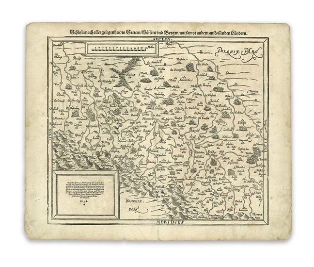
Schlesia nach aller gelegenheit in Stetten / Wassern und Bergen / mit sampt andern anstossenden Landern
1572
Woodcut; uncoloured
Printed area: 33.5 x 40.7 cm; 13.1 x 16 in
Munster's early map of Silesia is dated in text on verso "1587." It is named "Silesia after the description of M. Martini Helbigy." It is dedicated to the "most noble captain Niclaus Redinger," followed by a brief description of the most noteworthy geographic conditions.
Martin Hellwig, born 1515, is regarded as one of the most important humanists in the eastern provinces of Germany of the 16th Century. He worked as a teacher and geographer at the University of Wittenberg. He developed the first comprehensive map of Silesia, which served as a basis for future maps of the region for decades to come. The map's orientation is eastwards, making the north appear on the left-hand side. The geographical centre of the map is the town of Breslau. The network of rivers is shown schematically, with the Oder river dominating the map. The town of Liegnitz is placed centrally.
From the Legendary Vladi Collection of Historical Maps which includes 280 examples of the finest quality antique maps brought to auction with proceeds benefiting MapAction, an organization that uses maps and technology to aid those in disaster-stricken areas. Each map is accompanied by a certificate of authenticity issued by the consignor.
Condition: Center fold, right rupture of lower center fold, edge chippings on lower, upper and right margin, lower left and right corner, edge nick and repair of upper left corner, light brown discolouration, a few stains throughout map, text on verso in German.
This item will be shipped from Hamburg, Germany. Shipping details are to be coordinated with our recommended shipper
View it on
Estimate
Time, Location
Auction House
Munster, Sebastian
Schlesia nach aller gelegenheit in Stetten / Wassern und Bergen / mit sampt andern anstossenden Landern
1572
Woodcut; uncoloured
Printed area: 33.5 x 40.7 cm; 13.1 x 16 in
Munster's early map of Silesia is dated in text on verso "1587." It is named "Silesia after the description of M. Martini Helbigy." It is dedicated to the "most noble captain Niclaus Redinger," followed by a brief description of the most noteworthy geographic conditions.
Martin Hellwig, born 1515, is regarded as one of the most important humanists in the eastern provinces of Germany of the 16th Century. He worked as a teacher and geographer at the University of Wittenberg. He developed the first comprehensive map of Silesia, which served as a basis for future maps of the region for decades to come. The map's orientation is eastwards, making the north appear on the left-hand side. The geographical centre of the map is the town of Breslau. The network of rivers is shown schematically, with the Oder river dominating the map. The town of Liegnitz is placed centrally.
From the Legendary Vladi Collection of Historical Maps which includes 280 examples of the finest quality antique maps brought to auction with proceeds benefiting MapAction, an organization that uses maps and technology to aid those in disaster-stricken areas. Each map is accompanied by a certificate of authenticity issued by the consignor.
Condition: Center fold, right rupture of lower center fold, edge chippings on lower, upper and right margin, lower left and right corner, edge nick and repair of upper left corner, light brown discolouration, a few stains throughout map, text on verso in German.
This item will be shipped from Hamburg, Germany. Shipping details are to be coordinated with our recommended shipper


