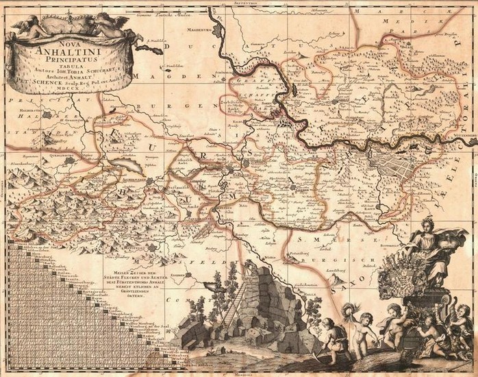
Nova Anhaltini Principatus Tabula.
Title/Content of Map: Nova Anhaltini Principatus Tabula.
Date: 1710
Cartographer: SCHUCHART, JOHANN TOBIAS
Publisher: PIETER SCHENK
Size: 17.5Height - 22.5Width
Autore Ioh.Tobia Schuchart, architect Anhalt..." Extremely decorative map of central Germany south of Magdeburg surrounded by Prussian Saxony. Bottom left is an interesting scale of German Meilen, distances between villages of Anhalt. Lower center is depicted a natural outcropping near Harzgerode called Teuffels-muehl, used as an observatolry in early times. Lower right are the arms of the Princes of Anhalt held by aloft by a muse while below putti practice the trades and agriculture of Anhalt. Title vignette upper left, below which are the towns of Halberstadt and Quedlinburg, in whose ancient abbey are buried the bones of King Heinrich I, known as Heinrich the German. Margins trimmed close to neat line, waterstained at bottom.
Reserve: $250.00
Shipping:
Domestic: Flat-rate of $18.00 to anywhere within the contiguous U.S.
International: Foreign shipping rates are determined by destination.
Combined shipping: Please ask about combined shipping for multiple lots before bidding.
Location: This item ships from Tennessee.
Your purchase is protected:
Photos, descriptions, and estimates were prepared with the utmost care by a fully certified expert and appraiser. All items in this sale are guaranteed authentic.
In the rare event that the item did not conform to the lot description in the sale, Jasper52 specialists are here to help. Buyers may return the item for a full refund provided you notify Jasper52 within 5 days of receiving the item.
Condition Report: Good
View it on
Estimate
Time, Location
Auction House
Title/Content of Map: Nova Anhaltini Principatus Tabula.
Date: 1710
Cartographer: SCHUCHART, JOHANN TOBIAS
Publisher: PIETER SCHENK
Size: 17.5Height - 22.5Width
Autore Ioh.Tobia Schuchart, architect Anhalt..." Extremely decorative map of central Germany south of Magdeburg surrounded by Prussian Saxony. Bottom left is an interesting scale of German Meilen, distances between villages of Anhalt. Lower center is depicted a natural outcropping near Harzgerode called Teuffels-muehl, used as an observatolry in early times. Lower right are the arms of the Princes of Anhalt held by aloft by a muse while below putti practice the trades and agriculture of Anhalt. Title vignette upper left, below which are the towns of Halberstadt and Quedlinburg, in whose ancient abbey are buried the bones of King Heinrich I, known as Heinrich the German. Margins trimmed close to neat line, waterstained at bottom.
Reserve: $250.00
Shipping:
Domestic: Flat-rate of $18.00 to anywhere within the contiguous U.S.
International: Foreign shipping rates are determined by destination.
Combined shipping: Please ask about combined shipping for multiple lots before bidding.
Location: This item ships from Tennessee.
Your purchase is protected:
Photos, descriptions, and estimates were prepared with the utmost care by a fully certified expert and appraiser. All items in this sale are guaranteed authentic.
In the rare event that the item did not conform to the lot description in the sale, Jasper52 specialists are here to help. Buyers may return the item for a full refund provided you notify Jasper52 within 5 days of receiving the item.
Condition Report: Good


