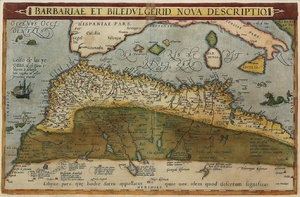
Ortelius Map of the Barbary Coast
Ortelius, Abraham (1527-1598).
Barbariae Et Biledulgerid Nova Descriptio.
Engraved map with original hand color.
Antwerp, 1574.
13 1/2" x 20" visible, 22" x 29" framed.
Ortelius' map of coastal North Africa and the Mediterranean, from Ortelius' Theatrum Orbis Terrarum, the first modern atlas of the world. The map extends from Morocco and the Sahara to Libya and shows most of the Mediterranean, including the Balearic Islands, Sicily, Corsica, Sardinia and Italy, along tih the Canaries off the coast of Africa.
View it on
Sale price
Estimate
Time, Location
Auction House
Ortelius, Abraham (1527-1598).
Barbariae Et Biledulgerid Nova Descriptio.
Engraved map with original hand color.
Antwerp, 1574.
13 1/2" x 20" visible, 22" x 29" framed.
Ortelius' map of coastal North Africa and the Mediterranean, from Ortelius' Theatrum Orbis Terrarum, the first modern atlas of the world. The map extends from Morocco and the Sahara to Libya and shows most of the Mediterranean, including the Balearic Islands, Sicily, Corsica, Sardinia and Italy, along tih the Canaries off the coast of Africa.


