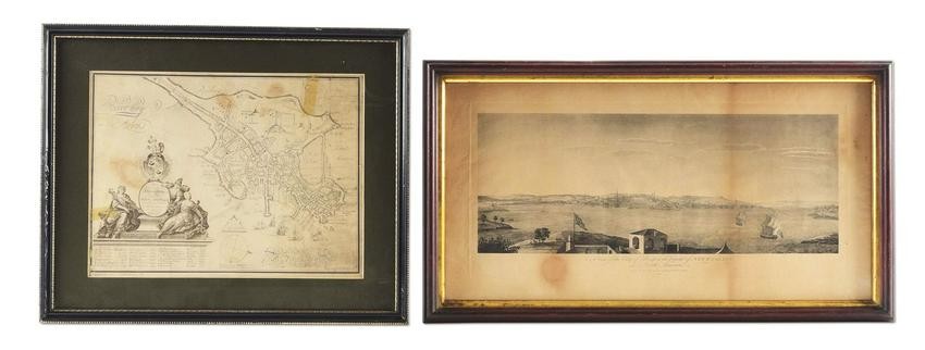
POWNALL 1761 VIEW AND BURGIS MAP OF BOSTON (LOT OF 2).
After Thomas Pownall (1722-1805), "A View of the City of Boston the Capital of NEW ENGLAND, in North America. Drawn on the Spot by his Excellency Governor Pownal. 1757", platemark: 9 3/4 x 21 inches; overall: 12 1/4 x 24 inches (view). Apparently a later restrike from the original 1761 R. C. Canot copperplate engraving printed by John Bowles, Robert Sayer, Thomas Jefferys, Carrington Bowles and Henry Parker. This famous view of Boston as viewed from Castle Island was drawn by Pownall, the recently retired governor of the Massachusetts Bay Colony and talented, amateur artist, which was engraved and issued as part of the extremely rare "Scenographia Americana" collection of 28 views. CONDITION: toned and with some staining, mostly along lower edge (not viewed outside of frame). [with] BURGIS, WILLIAM, After. "To His Excellency William Burnet, Esqr., this Plan of Boston in New England is humbly dedicated." The original was engraved in 1728 by Thomas Johnson & dedicated by William Burgis to Gov. William Burnet. It is a corrected & improved version of the first (1720) map of Boston, drawn by Captain John Bonner and is also the first to show the division of the town into wards. This is the 1869 reprint of the map, reproduced in gravure', 11 x 14 1/2 (view) within matted frame. CONDITION: light soiling, folds, creases and marginal tears, as well as one 2-inch, taped repair to the upper righthand corner (not viewed outside of frame). JLK Illustrated and discussed, respectively, on pp. 20-21 and 48-49 of "For Liberty I Live."
[ translate ]View it on
Sale price
Estimate
Time, Location
Auction House
After Thomas Pownall (1722-1805), "A View of the City of Boston the Capital of NEW ENGLAND, in North America. Drawn on the Spot by his Excellency Governor Pownal. 1757", platemark: 9 3/4 x 21 inches; overall: 12 1/4 x 24 inches (view). Apparently a later restrike from the original 1761 R. C. Canot copperplate engraving printed by John Bowles, Robert Sayer, Thomas Jefferys, Carrington Bowles and Henry Parker. This famous view of Boston as viewed from Castle Island was drawn by Pownall, the recently retired governor of the Massachusetts Bay Colony and talented, amateur artist, which was engraved and issued as part of the extremely rare "Scenographia Americana" collection of 28 views. CONDITION: toned and with some staining, mostly along lower edge (not viewed outside of frame). [with] BURGIS, WILLIAM, After. "To His Excellency William Burnet, Esqr., this Plan of Boston in New England is humbly dedicated." The original was engraved in 1728 by Thomas Johnson & dedicated by William Burgis to Gov. William Burnet. It is a corrected & improved version of the first (1720) map of Boston, drawn by Captain John Bonner and is also the first to show the division of the town into wards. This is the 1869 reprint of the map, reproduced in gravure', 11 x 14 1/2 (view) within matted frame. CONDITION: light soiling, folds, creases and marginal tears, as well as one 2-inch, taped repair to the upper righthand corner (not viewed outside of frame). JLK Illustrated and discussed, respectively, on pp. 20-21 and 48-49 of "For Liberty I Live."
[ translate ]


