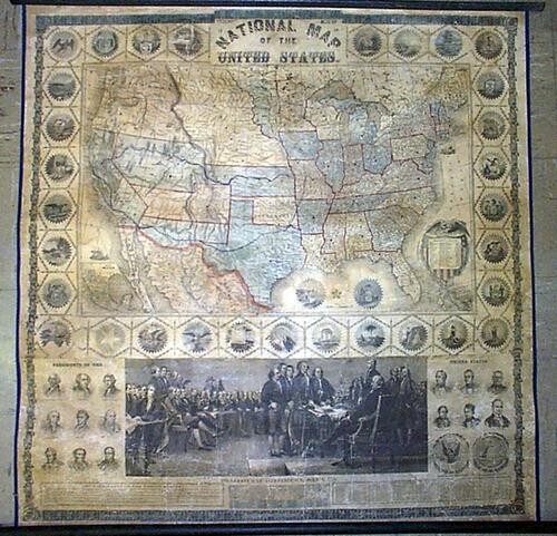
Phelps' New 1859 National Map of the United States.
Publication Date: 1859
Title: Phelps' New 1859 National Map of the United States.
Cartographer: Humphrey Phelps
Publisher: Phelps & Watson
Height: 37.5
Width: 36
Spectacular illustrated wall map on rods by a publisher best known for guide book maps. The US shows Nebraska extending north to Canada, a horizontal Arizona is spelled "Arizonia" [sic]. Colorado is divided between Utah and Kansas. Very large territories of Nebraska Washington, Utah, Kansas, and Arizona has its largest share of New Mexico. The map is surrounded by the state seals and below a large print with key of "Declaration of Independence, July 4, 1776". Also vignette portraits of the Presidents up to that time. Attractive period graphics. Rubbed in some spots. Professionally restored. Splendid display map / historical print. No map of this title has appeared in 25+ years of AMPR.
Reserve: $2,750.00
Shipping:
Domestic: Flat-rate of $45.00 to anywhere within the contiguous U.S.
International: Foreign shipping rates are determined by destination.
Combined shipping: Please ask about combined shipping for multiple lots before bidding.
Location: This item ships from Tennessee
Your purchase is protected:
Photos, descriptions, and estimates were prepared with the utmost care by a fully certified expert and appraiser. All items in this sale are guaranteed authentic.
In the rare event that the item did not conform to the lot description in the sale, Jasper52 specialists are here to help. Buyers may return the item for a full refund provided you notify Jasper52 within 5 days of receiving the item.
Condition Report: Good
View it on
Estimate
Time, Location
Auction House
Publication Date: 1859
Title: Phelps' New 1859 National Map of the United States.
Cartographer: Humphrey Phelps
Publisher: Phelps & Watson
Height: 37.5
Width: 36
Spectacular illustrated wall map on rods by a publisher best known for guide book maps. The US shows Nebraska extending north to Canada, a horizontal Arizona is spelled "Arizonia" [sic]. Colorado is divided between Utah and Kansas. Very large territories of Nebraska Washington, Utah, Kansas, and Arizona has its largest share of New Mexico. The map is surrounded by the state seals and below a large print with key of "Declaration of Independence, July 4, 1776". Also vignette portraits of the Presidents up to that time. Attractive period graphics. Rubbed in some spots. Professionally restored. Splendid display map / historical print. No map of this title has appeared in 25+ years of AMPR.
Reserve: $2,750.00
Shipping:
Domestic: Flat-rate of $45.00 to anywhere within the contiguous U.S.
International: Foreign shipping rates are determined by destination.
Combined shipping: Please ask about combined shipping for multiple lots before bidding.
Location: This item ships from Tennessee
Your purchase is protected:
Photos, descriptions, and estimates were prepared with the utmost care by a fully certified expert and appraiser. All items in this sale are guaranteed authentic.
In the rare event that the item did not conform to the lot description in the sale, Jasper52 specialists are here to help. Buyers may return the item for a full refund provided you notify Jasper52 within 5 days of receiving the item.
Condition Report: Good


