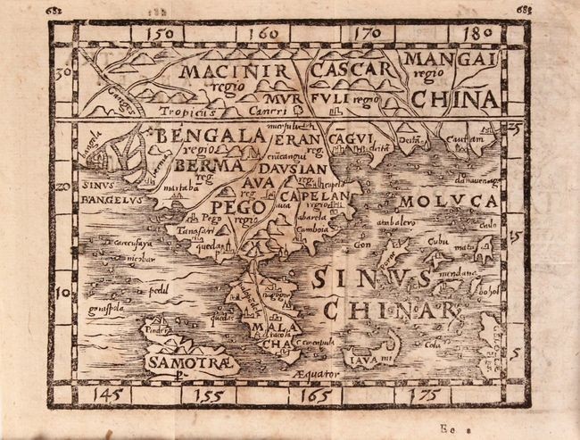
"Procli de Sphaera Liber I. Cleomedis de Mundo, sive Circularis Inspectionis Meteororum Libri II...", Honter, Jon Coronensis
Subject: Miscellaneous Books
Period: 1585 (published)
Color: Black & White
Size: 6.4 x 4.3
Johannes Honter first published his Rudimenta Cosmographica in 1530 with only two maps, and later expanded it to 14 maps for his 1546 edition. In 1561, a new set of blocks were cut by Heinrich Petri, now totaling 24 maps based on the same style as Honter's original maps. Heinrich Petri published a parallel publication to Honter's Rudimenta Cosmographica from 1561 to 1602 with these new maps to accompany classical texts, including Proclus' De Sphaera. This volume is complete with the 24 woodcut maps, printed back-to-back as was done in Honter's Rudimenta Cosmographica. The maps included are the world, Ireland, England & Scotland, France, Spain & Portugal, Mallorca, Germany, Zealand, Italy, Sicily, Greece, Euboea, Malta, Cyprus, Holy Land, India, Southeast Asia, Java Major, Sumatra (called Taprobana), Arabia & Ethopia, Northwestern Africa, Southern Africa, Madeira, and Cuba.
The heart-shaped world map is an updated version with North and South America completely redrawn. The map is surrounded by a border with stars, clouds, and windheads. Other important maps include Southeast Asia, with very odd island configurations in the East Indies; and Seelandia, which was the first separately published map of Zealand.
16mo, 738 pp. Hardbound in original vellum with old manuscript titling on spine. See also lot 819 for Rodney Shirley's excellent reference work, The Mapping of the World, which discusses this map.
References: Shirley (BL Atlases) T.HONT-2b; Shirley #108.
View it on
Sale price
Estimate
Time, Location
Auction House
Subject: Miscellaneous Books
Period: 1585 (published)
Color: Black & White
Size: 6.4 x 4.3
Johannes Honter first published his Rudimenta Cosmographica in 1530 with only two maps, and later expanded it to 14 maps for his 1546 edition. In 1561, a new set of blocks were cut by Heinrich Petri, now totaling 24 maps based on the same style as Honter's original maps. Heinrich Petri published a parallel publication to Honter's Rudimenta Cosmographica from 1561 to 1602 with these new maps to accompany classical texts, including Proclus' De Sphaera. This volume is complete with the 24 woodcut maps, printed back-to-back as was done in Honter's Rudimenta Cosmographica. The maps included are the world, Ireland, England & Scotland, France, Spain & Portugal, Mallorca, Germany, Zealand, Italy, Sicily, Greece, Euboea, Malta, Cyprus, Holy Land, India, Southeast Asia, Java Major, Sumatra (called Taprobana), Arabia & Ethopia, Northwestern Africa, Southern Africa, Madeira, and Cuba.
The heart-shaped world map is an updated version with North and South America completely redrawn. The map is surrounded by a border with stars, clouds, and windheads. Other important maps include Southeast Asia, with very odd island configurations in the East Indies; and Seelandia, which was the first separately published map of Zealand.
16mo, 738 pp. Hardbound in original vellum with old manuscript titling on spine. See also lot 819 for Rodney Shirley's excellent reference work, The Mapping of the World, which discusses this map.
References: Shirley (BL Atlases) T.HONT-2b; Shirley #108.


