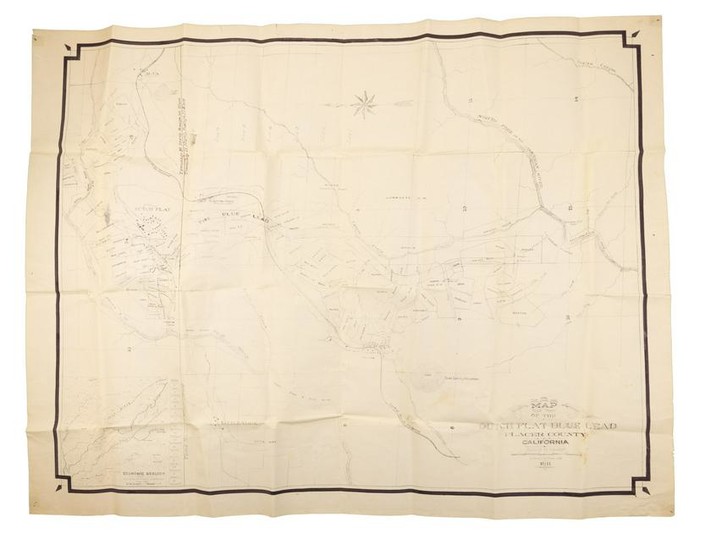
Rare map of Duch Flat CA and its mines
Heading: (California - Dutch Flat)
Author: Uren, Edward C.
Title: Map of the Dutch Flat Blue Lead Placer County California
Place Published: No place
Publisher:
Date Published: 1911
Description:
Blue line map. 85.5x111 cm 33¾x43¾"), folded.
Rare map showing the gold country settlement of Dutch Flat and the adjacent mines, crossed by Canyon Creek, Bear River, the North Fork of the American River, and the tracks of the Central Pacific Railroad. The mines and mining properties are identified, and the houses of Dutch Flat depicted. At lower left is an inset of the "Economic Geology from Government Surveys" of the larger region, with Dutch Flat at the center. No copies are found in OCLC.
Dutch Flat was one of the first mining camps where newly invented dynamite was extensively used in hydraulic mining to break up and collapse the gravel faces. The hydraulic mines in the area continued to produce fantastic amounts of gold well into the 1870's. A Chinese company reportedly found a $12,000 (period values) nugget in July of 1877. The gold at Dutch Flat assayed as high as .970 fine.
In 1895, the Polar Star and Southern Cross Mines were operated by drifting, followed by renewed hydraulic mining of the coarse blue lead gravels. In 1900, the Polar Star was using 2,800 inches of water under 450-foot head with 8 and 9 inch nozzles. This was only enough water to permit work for 5 hours a day.
A log debris dam was built in the Bear River and was used jointly by this mine and the Liberty Hill Mine in Nevada County to the north.
Drift mines that were active about the same time were the Dutch Flat Blue Lead Mine gold mine, which worked a cemented bottom gravel that required crushing in a 10-stamp mill, the Alta Mine, and the Bartley Consolidated Mine, which was on the branch channel coming from Alta. The latter two mines produced low-grade gravel from a drift-mining standpoint.
After 1914, there was no hydraulic mining, and drift and quartz mining were drastically reduced county-wide. By 1916, the only gold mines reported to be "active" in the district were the Rawhide Quartz, Federal Drift, Dyer Drift, Dutch Flat Drift, Haub Drift, Indian Hill Drift, Moody Ridge Drift, and Stewart Drift. Of those, only the Dyer Drift and Stewart Drift were reportedly producing, the remainder undergoing only assessment work.
Condition Report: Pinholes in corners, a few marginal tears and chips, one 2½" tear within the map; about very good.
View it on
Sale price
Estimate
Time, Location
Auction House
Heading: (California - Dutch Flat)
Author: Uren, Edward C.
Title: Map of the Dutch Flat Blue Lead Placer County California
Place Published: No place
Publisher:
Date Published: 1911
Description:
Blue line map. 85.5x111 cm 33¾x43¾"), folded.
Rare map showing the gold country settlement of Dutch Flat and the adjacent mines, crossed by Canyon Creek, Bear River, the North Fork of the American River, and the tracks of the Central Pacific Railroad. The mines and mining properties are identified, and the houses of Dutch Flat depicted. At lower left is an inset of the "Economic Geology from Government Surveys" of the larger region, with Dutch Flat at the center. No copies are found in OCLC.
Dutch Flat was one of the first mining camps where newly invented dynamite was extensively used in hydraulic mining to break up and collapse the gravel faces. The hydraulic mines in the area continued to produce fantastic amounts of gold well into the 1870's. A Chinese company reportedly found a $12,000 (period values) nugget in July of 1877. The gold at Dutch Flat assayed as high as .970 fine.
In 1895, the Polar Star and Southern Cross Mines were operated by drifting, followed by renewed hydraulic mining of the coarse blue lead gravels. In 1900, the Polar Star was using 2,800 inches of water under 450-foot head with 8 and 9 inch nozzles. This was only enough water to permit work for 5 hours a day.
A log debris dam was built in the Bear River and was used jointly by this mine and the Liberty Hill Mine in Nevada County to the north.
Drift mines that were active about the same time were the Dutch Flat Blue Lead Mine gold mine, which worked a cemented bottom gravel that required crushing in a 10-stamp mill, the Alta Mine, and the Bartley Consolidated Mine, which was on the branch channel coming from Alta. The latter two mines produced low-grade gravel from a drift-mining standpoint.
After 1914, there was no hydraulic mining, and drift and quartz mining were drastically reduced county-wide. By 1916, the only gold mines reported to be "active" in the district were the Rawhide Quartz, Federal Drift, Dyer Drift, Dutch Flat Drift, Haub Drift, Indian Hill Drift, Moody Ridge Drift, and Stewart Drift. Of those, only the Dyer Drift and Stewart Drift were reportedly producing, the remainder undergoing only assessment work.
Condition Report: Pinholes in corners, a few marginal tears and chips, one 2½" tear within the map; about very good.


