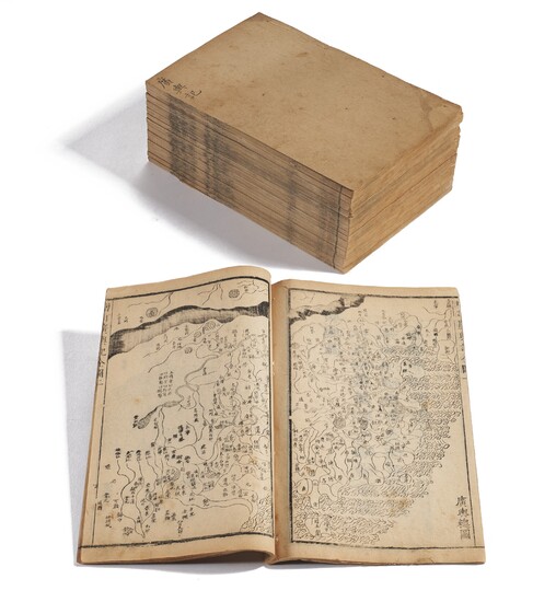
Revision of Records of the Vast Earth
CAI, Fangbing (1626-1709) ed. Zengding Guang Yu Ji [Revision of Records of the Vast Earth]. China, Kangxi period, 1686.
Comprehensive atlas of China during the Kangxi period, using traditional Chinese cartography. Most probably based on the Guang yutu (Enlarged terrestrial atlas, c. 1555) by Luo Hongxian (1504-1564), this work contains a general map of the Qing empire and fifteen provincial maps, all printed from woodblocks. Cordell Yee has observed that although Luo used a cartographic grid, this is absent from Cai’s work. The grid was ultimately derived from Matteo Ricci’s introduction of this cartographic method to China, but as Yee points out, the strength of indigenous Chinese cartographic tradition was such that it was not superseded by such western techniques until the 19th century. Despite the central government’s interest in the use of scalar techniques to enable careful surveying and therefore derive quantitative data, these gazetteers prefer to use pictorial representation. Instead, the textual descriptions of the geography provide the quantitative information. References: Cordell D.K. Yee, ‘Traditional Chinese Cartography and the Myth of Westernization’ in The History of Cartography, Vol. II, Book 2, pp.187-188.
15 volumes, small folio (225 x 170 mm). Woodcut printing including a general map of the Qing empire and fifteen provincial maps. (Toning, mostly marginal tears and wormholes, occasional soiling.) Thread-bound with Chinese wrappers; blue cloth folding case. Vol. 1 with title label, the other volumes with title written in ink directly on the cover; profusion of illustrations in vol. 1 (label chipping, tear from lower cover of vol. 1, binding threads loose or lost).
Please note that this lot is subject to an import tariff. If the buyer instructs Christie’s to arrange shipping of the lot to a foreign address, the buyer will not be required to pay the import tariff. If the buyer instructs Christie’s to arrange shipping of the lot to a domestic address, if the buyer collects the property in person, or if the buyer arranges their own shipping (whether domestically or internationally), the buyer will be required to pay the import tariff. Please contact Post Sale Services on +1 212 636 2650 prior to bidding for more information.
View it on
Estimate
Time, Location
Auction House
CAI, Fangbing (1626-1709) ed. Zengding Guang Yu Ji [Revision of Records of the Vast Earth]. China, Kangxi period, 1686.
Comprehensive atlas of China during the Kangxi period, using traditional Chinese cartography. Most probably based on the Guang yutu (Enlarged terrestrial atlas, c. 1555) by Luo Hongxian (1504-1564), this work contains a general map of the Qing empire and fifteen provincial maps, all printed from woodblocks. Cordell Yee has observed that although Luo used a cartographic grid, this is absent from Cai’s work. The grid was ultimately derived from Matteo Ricci’s introduction of this cartographic method to China, but as Yee points out, the strength of indigenous Chinese cartographic tradition was such that it was not superseded by such western techniques until the 19th century. Despite the central government’s interest in the use of scalar techniques to enable careful surveying and therefore derive quantitative data, these gazetteers prefer to use pictorial representation. Instead, the textual descriptions of the geography provide the quantitative information. References: Cordell D.K. Yee, ‘Traditional Chinese Cartography and the Myth of Westernization’ in The History of Cartography, Vol. II, Book 2, pp.187-188.
15 volumes, small folio (225 x 170 mm). Woodcut printing including a general map of the Qing empire and fifteen provincial maps. (Toning, mostly marginal tears and wormholes, occasional soiling.) Thread-bound with Chinese wrappers; blue cloth folding case. Vol. 1 with title label, the other volumes with title written in ink directly on the cover; profusion of illustrations in vol. 1 (label chipping, tear from lower cover of vol. 1, binding threads loose or lost).
Please note that this lot is subject to an import tariff. If the buyer instructs Christie’s to arrange shipping of the lot to a foreign address, the buyer will not be required to pay the import tariff. If the buyer instructs Christie’s to arrange shipping of the lot to a domestic address, if the buyer collects the property in person, or if the buyer arranges their own shipping (whether domestically or internationally), the buyer will be required to pay the import tariff. Please contact Post Sale Services on +1 212 636 2650 prior to bidding for more information.


