Samuel Hearne Map of Copper Mine River plus View of
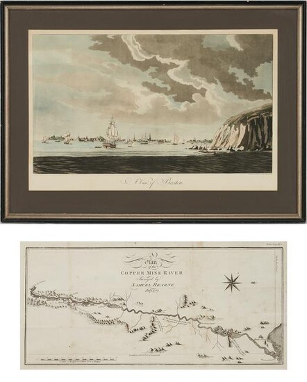
Early Canada Map plus Reproduction of Des Barres' View of Boston. 1st item: A PLAN OF THE COPPER MINE RIVER, SURVEYED BY SAMUEL HEARNE, JULY 1771. Early engraved Canada map, depicting the Coppermine River in the Hudson Bay / North Slave and Kitikmeot regions of the Northwest Territories and Nunavut. Image: 7 3/4" H x 17" W. Sheet: 11 1/4" H x 18 3/4" W. Likely source is Hearne's book, "A Journey from Prince of Wales's Fort in Hudson's Bay, to the Northern Ocean. Undertaken by order of the Hudson's Bay Company, for the discovery of copper mines, a north west passage, &c. In the years 1769, 1770, 1771, & 1772," London, Printed for A. Strahan and T. Cadell: and sold by T. Cadell Jun. and W. Davies, 1795. Note: As fur profits diminished in the late 18th century, the Hudson Bay Company developed a strategy to diversify into minerals and whaling. Royal Navy veteran Samuel Hearne and a Dene Indian guide named Matonabbee were dispatched to find a huge copper mine that Native North American Indians had described in the Arctic Overland. The explorers' dangerous 1700 mile journey, fraught with natural threats and battles with Natives, ended unsuccessfully with the discovery of only "rocks and gravel" rather than copper, but made Hearne "the first white man that ever gazed on the dreary expanse of the Arctic or Frozen Ocean from the northern shores of the Continent of America." [Sabin, 31181]. 2nd item: 20th century Reproduction print after Joseph Frederick Wallet Barres (1721-1824), depicting a Revolutionary War era view of Boston, possibly from the 1966 Barre Publishing "Neptune" portfolio. Matted and framed under glass in a silver and ebonized wood frame. Image: 28 1/4" H x 16 3/8" W. Sheet: 22" H x 33" W. Framed: 26" H x 36" W.
Condition Report: 1st item: Smudges, foxing at fold lines, tape repairs 5" and 2" at fold lines upper right edge from top and lower left edge from side. Minor foxing and edge wear. 2nd item: Light toning. Top and lower edges taped to mat. Shadow lines of previous backing (lettering) visible en verso; shadow line of previous object on backing (perhaps tape?) visible en verso and recto (upper left quadrant); note that tape has not been applied to the actual print.
View it on
Estimate
Time, Location
Auction House
Early Canada Map plus Reproduction of Des Barres' View of Boston. 1st item: A PLAN OF THE COPPER MINE RIVER, SURVEYED BY SAMUEL HEARNE, JULY 1771. Early engraved Canada map, depicting the Coppermine River in the Hudson Bay / North Slave and Kitikmeot regions of the Northwest Territories and Nunavut. Image: 7 3/4" H x 17" W. Sheet: 11 1/4" H x 18 3/4" W. Likely source is Hearne's book, "A Journey from Prince of Wales's Fort in Hudson's Bay, to the Northern Ocean. Undertaken by order of the Hudson's Bay Company, for the discovery of copper mines, a north west passage, &c. In the years 1769, 1770, 1771, & 1772," London, Printed for A. Strahan and T. Cadell: and sold by T. Cadell Jun. and W. Davies, 1795. Note: As fur profits diminished in the late 18th century, the Hudson Bay Company developed a strategy to diversify into minerals and whaling. Royal Navy veteran Samuel Hearne and a Dene Indian guide named Matonabbee were dispatched to find a huge copper mine that Native North American Indians had described in the Arctic Overland. The explorers' dangerous 1700 mile journey, fraught with natural threats and battles with Natives, ended unsuccessfully with the discovery of only "rocks and gravel" rather than copper, but made Hearne "the first white man that ever gazed on the dreary expanse of the Arctic or Frozen Ocean from the northern shores of the Continent of America." [Sabin, 31181]. 2nd item: 20th century Reproduction print after Joseph Frederick Wallet Barres (1721-1824), depicting a Revolutionary War era view of Boston, possibly from the 1966 Barre Publishing "Neptune" portfolio. Matted and framed under glass in a silver and ebonized wood frame. Image: 28 1/4" H x 16 3/8" W. Sheet: 22" H x 33" W. Framed: 26" H x 36" W.
Condition Report: 1st item: Smudges, foxing at fold lines, tape repairs 5" and 2" at fold lines upper right edge from top and lower left edge from side. Minor foxing and edge wear. 2nd item: Light toning. Top and lower edges taped to mat. Shadow lines of previous backing (lettering) visible en verso; shadow line of previous object on backing (perhaps tape?) visible en verso and recto (upper left quadrant); note that tape has not been applied to the actual print.


