U.S., North America, Canada; Henri Chatelain - Carte De La Nouvelle France - 1701-1720
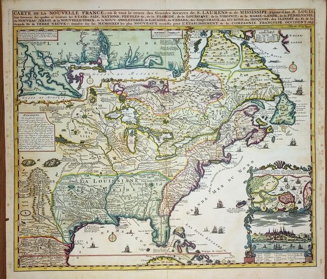
Original antique map of North America and Canada by Henri Chatelain. Carte De La Nouvelle France. Published in Amsterdam 1719 circa. From Chatelain's "Atlas Historique et Méthodique". Very good condition, a genuine antique map 300 years old. Beautiful map of eastern North America copied from De Fer, and designed to show the courses of the St. Laurence and the Mississippi rivers. Containing lots of inland detail with notes and vignettes of the indigenous peoples and fauna of North America and Canada. In an inset at top left the coast of Louisiana and the Mississippi valley, in another inset at bottom right a panoramic view and plan of Quebec City. The geography of New England and Eastern Canada originates with Franquelin. A large-scale map of the Mississippi delta and Mobile Bay, based on the voyage of Le Moyne is inset at top left. The map was issued to promote the newly established Compagnie Francoise Occident, which was formed to fund the debt of Louix XIV and offered inducements to encourage settlement in Louisiana. Title: Carte De La Nouvelle France, ou se voit le cours des Grandes Rivieres de. S. Laurens & de Mississipi. . Floride. . . Louisiane. . . Virginie. . . Marie-Lande. . . Nouvelle Yorck. . . Nouvelle Angleterre. . . Copper engraving. Excellent condition, taken directly from the original volumes, wide and original margins, superb quality, no particular cuts or defects to report, strong and thick paper. Size: Height 46. 5 x Width 51. 5 cm (18. 3 x 20. 3 inches) . Hand Coloured. Text in French. No text on verso. Author: Henri Abraham Chatelain (1684-1743) was a Huguenot pastor of Parisian origins. Chatelain proved a successful businessman, creating lucrative networks in London, The Hague, and then Amsterdam. He is most well known for the Atlas Historique, published in seven volumes between 1705 and 1720. This encyclopedic work was devoted to the history and genealogy of the continents, discussing such topics as geography, cosmography, topography, heraldry, and ethnography. Published thanks to a partnership between Henri, his father, Zacharie, and his younger brother, also Zacharie, the text was contributed to by Nicolas Gueudeville, a French geographer. The maps were by Henri, largely after the work of Guillaume Delisle, and they offered the general reader a window into the emerging world of the eighteenth century. Shipping: via UPS, DHL, National Postal Services, protected, INSURED and fully tracked package. Estimated time for Europe 3-8 working days.
[ translate ]View it on
Sale price
Estimate
Time, Location
Auction House
Original antique map of North America and Canada by Henri Chatelain. Carte De La Nouvelle France. Published in Amsterdam 1719 circa. From Chatelain's "Atlas Historique et Méthodique". Very good condition, a genuine antique map 300 years old. Beautiful map of eastern North America copied from De Fer, and designed to show the courses of the St. Laurence and the Mississippi rivers. Containing lots of inland detail with notes and vignettes of the indigenous peoples and fauna of North America and Canada. In an inset at top left the coast of Louisiana and the Mississippi valley, in another inset at bottom right a panoramic view and plan of Quebec City. The geography of New England and Eastern Canada originates with Franquelin. A large-scale map of the Mississippi delta and Mobile Bay, based on the voyage of Le Moyne is inset at top left. The map was issued to promote the newly established Compagnie Francoise Occident, which was formed to fund the debt of Louix XIV and offered inducements to encourage settlement in Louisiana. Title: Carte De La Nouvelle France, ou se voit le cours des Grandes Rivieres de. S. Laurens & de Mississipi. . Floride. . . Louisiane. . . Virginie. . . Marie-Lande. . . Nouvelle Yorck. . . Nouvelle Angleterre. . . Copper engraving. Excellent condition, taken directly from the original volumes, wide and original margins, superb quality, no particular cuts or defects to report, strong and thick paper. Size: Height 46. 5 x Width 51. 5 cm (18. 3 x 20. 3 inches) . Hand Coloured. Text in French. No text on verso. Author: Henri Abraham Chatelain (1684-1743) was a Huguenot pastor of Parisian origins. Chatelain proved a successful businessman, creating lucrative networks in London, The Hague, and then Amsterdam. He is most well known for the Atlas Historique, published in seven volumes between 1705 and 1720. This encyclopedic work was devoted to the history and genealogy of the continents, discussing such topics as geography, cosmography, topography, heraldry, and ethnography. Published thanks to a partnership between Henri, his father, Zacharie, and his younger brother, also Zacharie, the text was contributed to by Nicolas Gueudeville, a French geographer. The maps were by Henri, largely after the work of Guillaume Delisle, and they offered the general reader a window into the emerging world of the eighteenth century. Shipping: via UPS, DHL, National Postal Services, protected, INSURED and fully tracked package. Estimated time for Europe 3-8 working days.
[ translate ]
!["[On 4 Sheets] Geologic Map of the United States", U.S. Geological Survey (USGS) "[On 4 Sheets] Geologic Map of the United States", U.S. Geological Survey (USGS)](https://gcp-la8-storage-cdn.lot-art.com/public/upl/23/On-4-Sheets-Geologic-Map-of-the-United-States-US-Geological-Survey-USGS_66162f834528e-thumb-84668500_1712729987-66162f83cee10.jpg)


