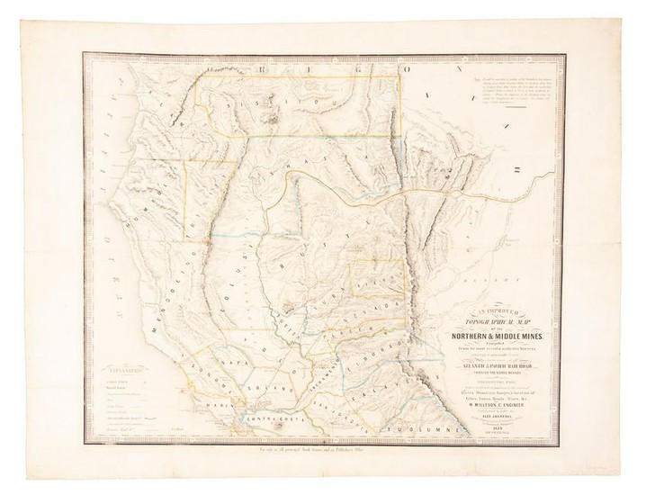
Zakreski map of California Gold Region 1854
Heading: (Zakreski, Alexander, publisher)
Author: Milleson, M.
Title: An Improved Topographical Map of the Northern & Middle Mines. Compiled from the most recent & authentic Surveys, showing a practicable Route for the great Atlantic & Pacific Railroad, through the Sierra Nevada at Fredonyers Pass. With a faithfull delineation of the course of Rivers, Mountain Ranges, & location of Cities, Towns, Roads, Mines, &c.c.
Place Published: San Francisco
Publisher:Published & lithd. by Alex. Zakreski
Date Published: 1854
Description:
Lithographed map, hand-colored in outline. 45.5x56 cm (17¾x22"), mounted on later linen backing.
Scarce map of Northern California, with details of the mining district in the north, around Coloma, and farther south, at Mockolumne Hill, Columbia, Sonora, etc. The Benicia-Marysville railroad is shown, and also a proposed route for the Atlantic to Pacific railroad. OCLC/WorldCat lists only six copies, and locates five of them, at Santa Clara University, the University of California Santa Cruz, the University of California Berkeley, the University of Southern Maine, and Yale. Originally issued as a folding map, with evidence of old folds visible, but they do not correspond to the size of the folded example we sold for Warren Heckrotte in 2015. Wheat Gold Rush 265; Streeter 2765.
Full title: An Improved Topographical Map of the Northern & Middle Mines. Compiled from the most recent & authentic Surveys, showing a practicable Route for the great Atlantic & Pacific Railroad, through the Sierra Nevada at Fredonyers Pass. With a faithfull delineation of the course of Rivers, Mountain Ranges, & location of Cities, Towns, Roads, Mines, &c.c. by M. Milleson, Cl. engineeer. Published & lithd. by Alex. Zakreski, at the Topographical Drawning Office. Cor. Washington & Montgomery 1854 San Francisco. | Engraved by H.Steinegger | Entered according to Act of Congress in the Year 1854 by Alex. Zakreski in the Clerks Office of the Destreict Court of the United States for the Northern District of the State of California. | For sale at all principal Book-Stores, and at Publisher's Office.
Condition Report: Minor soiling and toning, a bit of wear evident at the old fold marks; very good.
View it on
Sale price
Estimate
Time, Location
Auction House
Heading: (Zakreski, Alexander, publisher)
Author: Milleson, M.
Title: An Improved Topographical Map of the Northern & Middle Mines. Compiled from the most recent & authentic Surveys, showing a practicable Route for the great Atlantic & Pacific Railroad, through the Sierra Nevada at Fredonyers Pass. With a faithfull delineation of the course of Rivers, Mountain Ranges, & location of Cities, Towns, Roads, Mines, &c.c.
Place Published: San Francisco
Publisher:Published & lithd. by Alex. Zakreski
Date Published: 1854
Description:
Lithographed map, hand-colored in outline. 45.5x56 cm (17¾x22"), mounted on later linen backing.
Scarce map of Northern California, with details of the mining district in the north, around Coloma, and farther south, at Mockolumne Hill, Columbia, Sonora, etc. The Benicia-Marysville railroad is shown, and also a proposed route for the Atlantic to Pacific railroad. OCLC/WorldCat lists only six copies, and locates five of them, at Santa Clara University, the University of California Santa Cruz, the University of California Berkeley, the University of Southern Maine, and Yale. Originally issued as a folding map, with evidence of old folds visible, but they do not correspond to the size of the folded example we sold for Warren Heckrotte in 2015. Wheat Gold Rush 265; Streeter 2765.
Full title: An Improved Topographical Map of the Northern & Middle Mines. Compiled from the most recent & authentic Surveys, showing a practicable Route for the great Atlantic & Pacific Railroad, through the Sierra Nevada at Fredonyers Pass. With a faithfull delineation of the course of Rivers, Mountain Ranges, & location of Cities, Towns, Roads, Mines, &c.c. by M. Milleson, Cl. engineeer. Published & lithd. by Alex. Zakreski, at the Topographical Drawning Office. Cor. Washington & Montgomery 1854 San Francisco. | Engraved by H.Steinegger | Entered according to Act of Congress in the Year 1854 by Alex. Zakreski in the Clerks Office of the Destreict Court of the United States for the Northern District of the State of California. | For sale at all principal Book-Stores, and at Publisher's Office.
Condition Report: Minor soiling and toning, a bit of wear evident at the old fold marks; very good.


