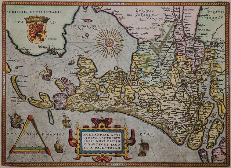
Hollandiae Antiquorum Catthorum Sedis Nova Descriptio
By Abraham Ortelius (1527 - 1598)
Es handelt sich hierbei um eine originale, kolorierte Kupferstich-Landkarte des Gebiets der Niederlande von Abraham Ortelius (1527 - 1598) aus dem Jahr 1602. *** Titel: Hollandiae Antiquorum Catthorum Sedis Nova Descriptio *** Gebiet bzw. Ort: Nord- und Südholland, Utrecht, Gelderland *** Kartograph: Abraham Ortelius (1527 - 1598) *** Jahr: 1602 *** Größe des Plattenbereichs: 36 x 49 cm *** Technik: Kupferstich *** Zustand (Perfekt/ Sehr gut/ Gut/ Ordentlich/ Mäßig/ Schlecht): In gutem Erhaltungszustand. Altersgemäß leicht gebräunt. *** Bemerkungen: Sehr dekorative und seltene, ostorientierte Karte Hollands im Altertum. Die Karte basiert auf Kartenmaterial von Jacob van Deventer und umfasst Nord- und Südholland, Utrecht und Gelderland. Ergänzt wird der Kartenbreich um eine aufwendige Kartusche, Wappen, Meilenanzeiger und Kompassrose sowie eine Vielzahl an Schiffen. Van den Broeke No. 1602S47. - - - International buyers welcome. If you have any questions, please don't hesitate to ask. --- Auf Wunsch stellen wir Ihnen gerne ein kostenfreies Echtheitszertifikat aus --- If you wish, we will gladly provide a certificate of authenticity free of charge ---
Publication year: 1602
Vendor: Kunstantiquariat Andreas Senger
Buy Now on
By Abraham Ortelius (1527 - 1598)
Es handelt sich hierbei um eine originale, kolorierte Kupferstich-Landkarte des Gebiets der Niederlande von Abraham Ortelius (1527 - 1598) aus dem Jahr 1602. *** Titel: Hollandiae Antiquorum Catthorum Sedis Nova Descriptio *** Gebiet bzw. Ort: Nord- und Südholland, Utrecht, Gelderland *** Kartograph: Abraham Ortelius (1527 - 1598) *** Jahr: 1602 *** Größe des Plattenbereichs: 36 x 49 cm *** Technik: Kupferstich *** Zustand (Perfekt/ Sehr gut/ Gut/ Ordentlich/ Mäßig/ Schlecht): In gutem Erhaltungszustand. Altersgemäß leicht gebräunt. *** Bemerkungen: Sehr dekorative und seltene, ostorientierte Karte Hollands im Altertum. Die Karte basiert auf Kartenmaterial von Jacob van Deventer und umfasst Nord- und Südholland, Utrecht und Gelderland. Ergänzt wird der Kartenbreich um eine aufwendige Kartusche, Wappen, Meilenanzeiger und Kompassrose sowie eine Vielzahl an Schiffen. Van den Broeke No. 1602S47. - - - International buyers welcome. If you have any questions, please don't hesitate to ask. --- Auf Wunsch stellen wir Ihnen gerne ein kostenfreies Echtheitszertifikat aus --- If you wish, we will gladly provide a certificate of authenticity free of charge ---
Publication year: 1602
Vendor: Kunstantiquariat Andreas Senger


![ORTELIUS, ABRAHAM. 1527-1598. Americae sive novi orbis, nova descriptio. [Antwerp]... ORTELIUS, ABRAHAM. 1527-1598. Americae sive novi orbis, nova descriptio. [Antwerp]...](https://gcp-la8-storage-cdn.lot-art.com/public/upl/43/ORTELIUS-ABRAHAM-1527-1598-Americae-sive-novi-orbis-nova-descriptio-Antwerp_661764a502ab1-thumb-85772700_1712809125-661764a5d168e.jpg)


