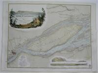
Plans of the River St. Lawrence below Quebec. Sheet 7. Quebec and Isle of Orleans.
By Bayfield
This map was engraved by J. & C. Walker and sold by J.D. Potter.A superb 19th century map of Quebec City and vicinity. The map focuses of the Isle of Orleans and the surrounding St. Lawrence waterways. A decorative vignette scene of Quebec City cartouche appears in the upper left.Captain Bayfield was a prominent English surveyor of the Admiralty who surveyed the Great Lakes and St. Lawrence river., Size : 455x600 (mm), 17.875x23.625 (Inches), Hand Colored
Published by: Office of the Admiralty, London, 1861
Vendor: Alexandre Antique Prints, Maps & Books
Buy Now on
By Bayfield
This map was engraved by J. & C. Walker and sold by J.D. Potter.A superb 19th century map of Quebec City and vicinity. The map focuses of the Isle of Orleans and the surrounding St. Lawrence waterways. A decorative vignette scene of Quebec City cartouche appears in the upper left.Captain Bayfield was a prominent English surveyor of the Admiralty who surveyed the Great Lakes and St. Lawrence river., Size : 455x600 (mm), 17.875x23.625 (Inches), Hand Colored
Published by: Office of the Admiralty, London, 1861
Vendor: Alexandre Antique Prints, Maps & Books


