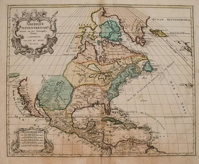
1792 Elwe Map of North America -- Amerique
Title/Content of Map: 1792 Elwe Map of North America -- Amerique Septentrionale Divisee en Ses Principales Parties
Date: 1792, Amsterdam
Cartographer: J Elwe
Size: 18.3 X 23.1 in.
This is an outstanding and quite unusual double page map of North America.The map shows marginal understanding of most of today's US and Canada.The Great Lakes are somewhat misshaped and feed the Mississippi. California Island is updated to be shown to be peninsular.Buttons Bay is open-ended, allowing the possibility of an inland passage to the Pacific. The R. del Norte originates from a large lake and empties into the Mer Rouge (Gulf of California).Some Native American tribes are shown -- Apache, Navajo, Illinois, Siox, etc. The political divisions are outdated with the continent still divided between the colonial interests of England, France and Spain.Possibly the plate was acquired at the dissolution of the Jaillot firm in 1781, and revised by Elwe.From Elwe's monumental 'Atlas'.
Reserve: $800.00
Shipping:
Domestic: Flat-rate of $20.00 to anywhere within the contiguous U.S.
International: Foreign shipping rates are determined by destination.
Combined shipping: Please ask about combined shipping for multiple lots before bidding.
Location: This item ships from Ohio
Your purchase is protected:
Photos, descriptions, and estimates were prepared with the utmost care by a fully certified expert and appraiser. All items in this sale are guaranteed authentic.
In the rare event that the item did not conform to the lot description in the sale, Jasper52 specialists are here to help. Buyers may return the item for a full refund provided you notify Jasper52 within 5 days of receiving the item.
Condition Report: Good-fair.Nice strike on watermarked laid paper.Slight damp stain at bottom and top portion of issued centerfold, into map.Beautiful original hand color.
View it on
Estimate
Time, Location
Auction House
Title/Content of Map: 1792 Elwe Map of North America -- Amerique Septentrionale Divisee en Ses Principales Parties
Date: 1792, Amsterdam
Cartographer: J Elwe
Size: 18.3 X 23.1 in.
This is an outstanding and quite unusual double page map of North America.The map shows marginal understanding of most of today's US and Canada.The Great Lakes are somewhat misshaped and feed the Mississippi. California Island is updated to be shown to be peninsular.Buttons Bay is open-ended, allowing the possibility of an inland passage to the Pacific. The R. del Norte originates from a large lake and empties into the Mer Rouge (Gulf of California).Some Native American tribes are shown -- Apache, Navajo, Illinois, Siox, etc. The political divisions are outdated with the continent still divided between the colonial interests of England, France and Spain.Possibly the plate was acquired at the dissolution of the Jaillot firm in 1781, and revised by Elwe.From Elwe's monumental 'Atlas'.
Reserve: $800.00
Shipping:
Domestic: Flat-rate of $20.00 to anywhere within the contiguous U.S.
International: Foreign shipping rates are determined by destination.
Combined shipping: Please ask about combined shipping for multiple lots before bidding.
Location: This item ships from Ohio
Your purchase is protected:
Photos, descriptions, and estimates were prepared with the utmost care by a fully certified expert and appraiser. All items in this sale are guaranteed authentic.
In the rare event that the item did not conform to the lot description in the sale, Jasper52 specialists are here to help. Buyers may return the item for a full refund provided you notify Jasper52 within 5 days of receiving the item.
Condition Report: Good-fair.Nice strike on watermarked laid paper.Slight damp stain at bottom and top portion of issued centerfold, into map.Beautiful original hand color.


