BLEAU Willem Janszoon (1571 - 1638), GOOS Pieter (c. 1616 - 1675)
BLEAU Willem Janszoon (1571 - 1638), GOOS Pieter (c. 1616 - 1675)
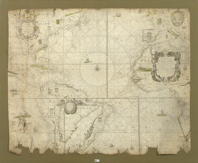
"West-Indische Paskaert ... Gedruckt t' Amsterdam Bij Pieter Goos Op 't Water inde Vers gulde Zee-Spiegel" rare and exceptional printed and watercolored nautical chart on vellum pasted on panel, extending mainly from South America to Greenland and from the Cape of Good Hope to Holland. After Willem Blaeu, geographer and publisher, on the Mercator projection. Printed by Pieter Goos in Amsterdam. Dutch school. Period: 17th century. (* and **). Dim. :+/-80x98,5cm. _x000D_
Blaeu's nautical chart is a scientific document of the first order which marks an important stage in the history of marine cartography in the 17th century. It is one of the first truly navigable general charts of American waters printed on vellum because it is more durable than paper for use at sea._x000D_
This chart was probably used for many decades as the master chart of the Dutch West India Company for North America, the Caribbean and South America._x000D_
Nautical charts printed on vellum are extremely rare on the market. Because of its strength, vellum was for many years the ideal medium for use at sea, and virtually all of the surviving examples were used for this purpose.x000D_
They could be used several times and still make tracks for each voyage. These tracks could be erased after an expedition in order to find a blank copy for the next departure.x000D_
In contrast, paper charts of this period were usually linked to atlases used by merchants, bankers and others working on land. When used at sea, they did not have the longevity of a vellum chart.
Today, these charts are particularly prized by collectors and institutions, as they were the actual navigational tools used at sea by sailors on voyages of discovery, on commercial expeditions, or in naval battles.x000D_
A similar copy on vellum is kept in the National Library of Poland in Warsaw.
Three similar copies on paper are in the Scheepvaart Museum in Amsterdam, the Maritime Museum in Rotterdam; and the British Admiralty Library.
Automatically translated by DeepL. The original version is the only legally valid version.
To see the original version, click here.
View it on
Estimate
Time, Location
Auction House
BLEAU Willem Janszoon (1571 - 1638), GOOS Pieter (c. 1616 - 1675)
"West-Indische Paskaert ... Gedruckt t' Amsterdam Bij Pieter Goos Op 't Water inde Vers gulde Zee-Spiegel" rare and exceptional printed and watercolored nautical chart on vellum pasted on panel, extending mainly from South America to Greenland and from the Cape of Good Hope to Holland. After Willem Blaeu, geographer and publisher, on the Mercator projection. Printed by Pieter Goos in Amsterdam. Dutch school. Period: 17th century. (* and **). Dim. :+/-80x98,5cm. _x000D_
Blaeu's nautical chart is a scientific document of the first order which marks an important stage in the history of marine cartography in the 17th century. It is one of the first truly navigable general charts of American waters printed on vellum because it is more durable than paper for use at sea._x000D_
This chart was probably used for many decades as the master chart of the Dutch West India Company for North America, the Caribbean and South America._x000D_
Nautical charts printed on vellum are extremely rare on the market. Because of its strength, vellum was for many years the ideal medium for use at sea, and virtually all of the surviving examples were used for this purpose.x000D_
They could be used several times and still make tracks for each voyage. These tracks could be erased after an expedition in order to find a blank copy for the next departure.x000D_
In contrast, paper charts of this period were usually linked to atlases used by merchants, bankers and others working on land. When used at sea, they did not have the longevity of a vellum chart.
Today, these charts are particularly prized by collectors and institutions, as they were the actual navigational tools used at sea by sailors on voyages of discovery, on commercial expeditions, or in naval battles.x000D_
A similar copy on vellum is kept in the National Library of Poland in Warsaw.
Three similar copies on paper are in the Scheepvaart Museum in Amsterdam, the Maritime Museum in Rotterdam; and the British Admiralty Library.
Automatically translated by DeepL. The original version is the only legally valid version.
To see the original version, click here.


