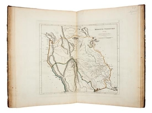
* CAREY, Matthew. Carey's General Atlas. Philadelphia: M. Carey, 1816.
Folio (418 x 282 mm). 58 engraved maps with contemporary hand-coloring in outline mounted on stubs (50 double-page). (Short tear repaired to title-page, maps of Vermont and New Hampshire with tears crossing image repaired on verso, a few minor most marginal stains.) Contemporary calf-backed marbled boards (some overall wear).
Presumed fifth edition of Carey's atlas first published in 1796, including new delineations of many midwestern states and territories. Important additions include maps of the Mississippi Territory, Ohio, the "Upper Territories," the Missouri Territory, and Louisiana. See Phillips 722 (the 1814 edition); not in Rumsey; see Sabin 10858 (mentioning the 1796, 1800, 1814 and 1818 editions only). RARE. [Laid in:] Portions of the front pages of two newspapers: The New York Journal of Commerce, 12 October 1850, with map showing the boundaries of the states of California and Texas and the territories of New Mexico and Utah; The New York Herald, 12 October 1863, with a map showing the positions of the French in Mexico.
Provenance: Arthur C. Swinton (early signature); Frederick F. Cornell (signature dated 1835).
View it on
Sale price
Estimate
Time, Location
Auction House
Folio (418 x 282 mm). 58 engraved maps with contemporary hand-coloring in outline mounted on stubs (50 double-page). (Short tear repaired to title-page, maps of Vermont and New Hampshire with tears crossing image repaired on verso, a few minor most marginal stains.) Contemporary calf-backed marbled boards (some overall wear).
Presumed fifth edition of Carey's atlas first published in 1796, including new delineations of many midwestern states and territories. Important additions include maps of the Mississippi Territory, Ohio, the "Upper Territories," the Missouri Territory, and Louisiana. See Phillips 722 (the 1814 edition); not in Rumsey; see Sabin 10858 (mentioning the 1796, 1800, 1814 and 1818 editions only). RARE. [Laid in:] Portions of the front pages of two newspapers: The New York Journal of Commerce, 12 October 1850, with map showing the boundaries of the states of California and Texas and the territories of New Mexico and Utah; The New York Herald, 12 October 1863, with a map showing the positions of the French in Mexico.
Provenance: Arthur C. Swinton (early signature); Frederick F. Cornell (signature dated 1835).


