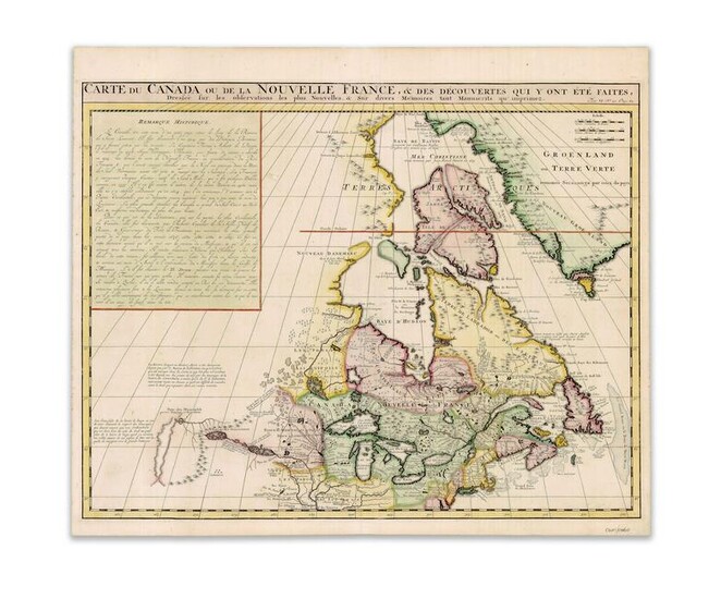
Chatelain, HA. Carte du Canada ou de la Nouvelle France
Chatelain, Henri Abraham
Carte du Canada ou de la Nouvelle France...
1718
Copperplate engraving; coloured
Printed area: 53 x 41.5 cm; 20.9 x 16.3 in
An important map in the history of Canada from the 'Atlas Historique'. It draws on Delisle's famous 1703 map of Canada and is accurate for its time. A box of the top left-hand side has French text detailing the history of the area from Jacques Cartier to the time of publication. Around Hudson's Bay and Labrador are natives listed as 'Christinaux', 'Kilistinons', 'Eskimaux'. At the coast are the names of explorers and the dates of discovery. A common cartographical error is the 'riviere longue', an imaginary river that was supposed to flow from 'Pays des Gnacsitares' to the Pacific.
From the Legendary Vladi Collection of Historical Maps which includes 280 examples of the finest quality antique maps brought to auction with proceeds benefiting MapAction, an organization that uses maps and technology to aid those in disaster-stricken areas. Each map is accompanied by a certificate of authenticity issued by the consignor.
Condition: Center fold, markings on lower right margin, light staining on margin and printed area; overall in very good condition.
This item will be shipped from Halifax, Canada. Shipping details are to be coordinated by the buyer with our recommended shipper.
View it on
Estimate
Time, Location
Auction House
Chatelain, Henri Abraham
Carte du Canada ou de la Nouvelle France...
1718
Copperplate engraving; coloured
Printed area: 53 x 41.5 cm; 20.9 x 16.3 in
An important map in the history of Canada from the 'Atlas Historique'. It draws on Delisle's famous 1703 map of Canada and is accurate for its time. A box of the top left-hand side has French text detailing the history of the area from Jacques Cartier to the time of publication. Around Hudson's Bay and Labrador are natives listed as 'Christinaux', 'Kilistinons', 'Eskimaux'. At the coast are the names of explorers and the dates of discovery. A common cartographical error is the 'riviere longue', an imaginary river that was supposed to flow from 'Pays des Gnacsitares' to the Pacific.
From the Legendary Vladi Collection of Historical Maps which includes 280 examples of the finest quality antique maps brought to auction with proceeds benefiting MapAction, an organization that uses maps and technology to aid those in disaster-stricken areas. Each map is accompanied by a certificate of authenticity issued by the consignor.
Condition: Center fold, markings on lower right margin, light staining on margin and printed area; overall in very good condition.
This item will be shipped from Halifax, Canada. Shipping details are to be coordinated by the buyer with our recommended shipper.


