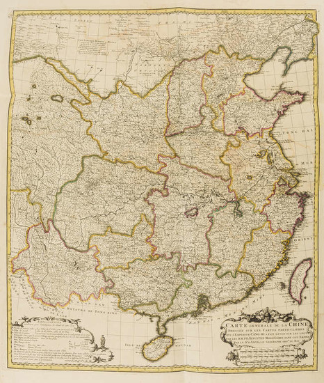
China.- d'Anville (Jean Baptiste Bourguignon) Nouvel Atlas de la Chine, de la Tartarie Chinoise, et du Thibet, 1737.
China.- d'Anville (Jean Baptiste Bourguignon) Nouvel Atlas de la Chine, de la Tartarie Chinoise, et du Thibet, title page printed in red and black, 42 engraved maps, some double-page or folding, contemporary outline colour, some worming affecting text rather than maps, the majority of the maps with damp-stains in the upper right quadrant, the majority of the maps with areas of loss in the upper corner quadrants repaired and reinstated with pen and ink, the latter half with larger areas repaired and condition deteriorating towards end of atlas, effecting both maps and margins, three maps with margins trimmed, otherwise browning and surface dirt throughout, contemporary red morocco, gilt, rubbed and worn, re-cased preserving spine, large folio measuring approx. 530 x 385 mm., The Hague, Henri Scheurleer, 1737; sold not subject to return.
⁂ The first scientific mapping of China, deriving from a triangulated survey carried out by French Jesuits, at the behest of the Emperor Kang Hsi. It forms the most important cartographic record of China from the eighteenth century.
View it on
Sale price
Estimate
Time, Location
Auction House
China.- d'Anville (Jean Baptiste Bourguignon) Nouvel Atlas de la Chine, de la Tartarie Chinoise, et du Thibet, title page printed in red and black, 42 engraved maps, some double-page or folding, contemporary outline colour, some worming affecting text rather than maps, the majority of the maps with damp-stains in the upper right quadrant, the majority of the maps with areas of loss in the upper corner quadrants repaired and reinstated with pen and ink, the latter half with larger areas repaired and condition deteriorating towards end of atlas, effecting both maps and margins, three maps with margins trimmed, otherwise browning and surface dirt throughout, contemporary red morocco, gilt, rubbed and worn, re-cased preserving spine, large folio measuring approx. 530 x 385 mm., The Hague, Henri Scheurleer, 1737; sold not subject to return.
⁂ The first scientific mapping of China, deriving from a triangulated survey carried out by French Jesuits, at the behest of the Emperor Kang Hsi. It forms the most important cartographic record of China from the eighteenth century.


