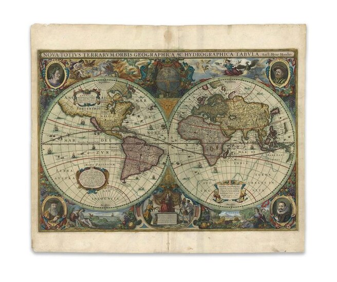
Hondius, H. Nova Totius Terrarum Orbis Geographica...
Hondius, Henricus
Nova Totius Terrarum Orbis Geographica ac Hydrographica Tabula
1630
Copperplate engraving; old coloured
Printed area: 54 x 38 cm; 21.3 x 14.9 in
One of the first world maps to appear in an atlas showing California as an island, and 'the oldest dated map in an atlas on which a Dutch discovery in Australia has been shown.The decoration on the map is superb: there are three strapwork catouches on the map; portraits of Julius Caesar, Ptolomy, Mercator and Jodocus Hondius fill the corners; scenes representing the four Elements are above and below each hemisphere; in the upper cusp are allegorical figures representing Asia, America, and Africa making obeisance to Europe.
Reference: This example is from the first issue, published in L'Appendice de l'Atlas de Gerard Mercator et Iodocus Hondius, in which a number of new maps were premiered.
From the Legendary Vladi Collection of Historical Maps which includes 280 examples of the finest quality antique maps brought to auction with proceeds benefiting MapAction, an organization that uses maps and technology to aid those in disaster-stricken areas. Each map is accompanied by a certificate of authenticity issued by the consignor.
Condition: Center fold, edge chippings on upper and lower left margin, light staining on margins, one stain on center fold of upper margin, text on verso; printed area in excellent condition.
This item will be shipped from Hamburg, Germany. Shipping details are to be coordinated with our recommended shipper
View it on
Estimate
Time, Location
Auction House
Hondius, Henricus
Nova Totius Terrarum Orbis Geographica ac Hydrographica Tabula
1630
Copperplate engraving; old coloured
Printed area: 54 x 38 cm; 21.3 x 14.9 in
One of the first world maps to appear in an atlas showing California as an island, and 'the oldest dated map in an atlas on which a Dutch discovery in Australia has been shown.The decoration on the map is superb: there are three strapwork catouches on the map; portraits of Julius Caesar, Ptolomy, Mercator and Jodocus Hondius fill the corners; scenes representing the four Elements are above and below each hemisphere; in the upper cusp are allegorical figures representing Asia, America, and Africa making obeisance to Europe.
Reference: This example is from the first issue, published in L'Appendice de l'Atlas de Gerard Mercator et Iodocus Hondius, in which a number of new maps were premiered.
From the Legendary Vladi Collection of Historical Maps which includes 280 examples of the finest quality antique maps brought to auction with proceeds benefiting MapAction, an organization that uses maps and technology to aid those in disaster-stricken areas. Each map is accompanied by a certificate of authenticity issued by the consignor.
Condition: Center fold, edge chippings on upper and lower left margin, light staining on margins, one stain on center fold of upper margin, text on verso; printed area in excellent condition.
This item will be shipped from Hamburg, Germany. Shipping details are to be coordinated with our recommended shipper


