Japanese Map of China
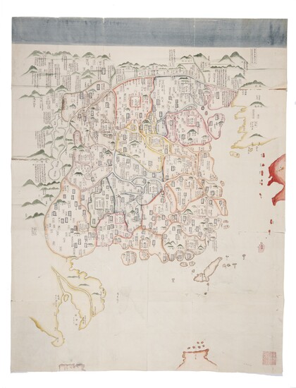
[Map of China. Japan, Edo period, 1664-1700.]
Beautiful Edo period map of China from the collection of Matsudaira Sadamichi. The map centers on China, with Korea painted at the upper right corner, below which one can see western Japan. The Philippines is rendered at the bottom part of the map and Vietnam, Cambodia and Thailand at the lower left section. The elaborate annotations of places in China demonstrate an interest in the historical development and events related to the place. An annotation of Liaodong at the upper right reading “it is named Fengtian Prefecture by the current Qing court” indicates that the map was produced in the Qing dynasty (1644-1912). The map represents the two capitals and thirteen provinces. Huguang Province was divided into Huanan and Hubei Provinces in 1664 by Emperor Kangxi. In the present lot, however, Huguang Province remains intact. Thus, the map depicts the territory of China before 1664, and theoretically the map should be executed before or around 1664. However, taking into consideration the possibility of information delay, as this map was not produced in China, 1644-1700 may be a safer range of date for the present lot. A collector’s seal is stamped at the lower right corner, reading “Isshu Kan Korekushon (Collection of Isshu Chamber).” This is probably a seal of Matsudaira Sadamichi (1804-1835), whose sobriquet is Isshu and his anthology of Chinese poems is entitled “Isshu Kan Yikou (Isshu Chamber’s Posthumous Manuscripts).” He was the eleventh feudal lord of Iyo-Matsuyama Domain during the Edo period, Japan. Maps like the present lot played a very important part in cultivating the geographical knowledge of China among the Japanese people in the latter part of the Edo period.
Manuscript map of China, ink and color on Japanese paper, approximately 1255 x 965 mm, folded in panels to 250 x 165 mm. Beige front and rear paper board covers attached to the back, white title strip on the front cover, two lines of Korean text written on the front cover reading: “colored map of China, Joseon and Japan,” with the dimensions of the map unfold “97 x 125.” On recto, a wide horizontal blue border on top, administrative divisions and islands all painted in distinctive pale colors, with darker inner contour lines, mountain peaks colored in dark green. Place names and annotations in Chinese, except for some islands with Japanese names. A seal stamped at the lower right corner. Very good condition with vivid colors (scattered small wormholes with minimal loss, tears along the margins and folds, some separation at folds, board covers with dampstains and chipped, revealing the darkened paper board inside; title strip almost lost, with only two partial characters remaining). Provenance: Matsudaira Sadamichi, 1804-1835 (collector's stamp).
Exhibited: "The World on Paper: From Square to Sphericity," Hong Kong Maritime Museum, December 2019 to March 2020.
Please note that this lot is subject to an import tariff. If the buyer instructs Christie’s to arrange shipping of the lot to a foreign address, the buyer will not be required to pay the import tariff. If the buyer instructs Christie’s to arrange shipping of the lot to a domestic address, if the buyer collects the property in person, or if the buyer arranges their own shipping (whether domestically or internationally), the buyer will be required to pay the import tariff. Please contact Post Sale Services on +1 212 636 2650 prior to bidding for more information.
View it on
Estimate
Time, Location
Auction House
[Map of China. Japan, Edo period, 1664-1700.]
Beautiful Edo period map of China from the collection of Matsudaira Sadamichi. The map centers on China, with Korea painted at the upper right corner, below which one can see western Japan. The Philippines is rendered at the bottom part of the map and Vietnam, Cambodia and Thailand at the lower left section. The elaborate annotations of places in China demonstrate an interest in the historical development and events related to the place. An annotation of Liaodong at the upper right reading “it is named Fengtian Prefecture by the current Qing court” indicates that the map was produced in the Qing dynasty (1644-1912). The map represents the two capitals and thirteen provinces. Huguang Province was divided into Huanan and Hubei Provinces in 1664 by Emperor Kangxi. In the present lot, however, Huguang Province remains intact. Thus, the map depicts the territory of China before 1664, and theoretically the map should be executed before or around 1664. However, taking into consideration the possibility of information delay, as this map was not produced in China, 1644-1700 may be a safer range of date for the present lot. A collector’s seal is stamped at the lower right corner, reading “Isshu Kan Korekushon (Collection of Isshu Chamber).” This is probably a seal of Matsudaira Sadamichi (1804-1835), whose sobriquet is Isshu and his anthology of Chinese poems is entitled “Isshu Kan Yikou (Isshu Chamber’s Posthumous Manuscripts).” He was the eleventh feudal lord of Iyo-Matsuyama Domain during the Edo period, Japan. Maps like the present lot played a very important part in cultivating the geographical knowledge of China among the Japanese people in the latter part of the Edo period.
Manuscript map of China, ink and color on Japanese paper, approximately 1255 x 965 mm, folded in panels to 250 x 165 mm. Beige front and rear paper board covers attached to the back, white title strip on the front cover, two lines of Korean text written on the front cover reading: “colored map of China, Joseon and Japan,” with the dimensions of the map unfold “97 x 125.” On recto, a wide horizontal blue border on top, administrative divisions and islands all painted in distinctive pale colors, with darker inner contour lines, mountain peaks colored in dark green. Place names and annotations in Chinese, except for some islands with Japanese names. A seal stamped at the lower right corner. Very good condition with vivid colors (scattered small wormholes with minimal loss, tears along the margins and folds, some separation at folds, board covers with dampstains and chipped, revealing the darkened paper board inside; title strip almost lost, with only two partial characters remaining). Provenance: Matsudaira Sadamichi, 1804-1835 (collector's stamp).
Exhibited: "The World on Paper: From Square to Sphericity," Hong Kong Maritime Museum, December 2019 to March 2020.
Please note that this lot is subject to an import tariff. If the buyer instructs Christie’s to arrange shipping of the lot to a foreign address, the buyer will not be required to pay the import tariff. If the buyer instructs Christie’s to arrange shipping of the lot to a domestic address, if the buyer collects the property in person, or if the buyer arranges their own shipping (whether domestically or internationally), the buyer will be required to pay the import tariff. Please contact Post Sale Services on +1 212 636 2650 prior to bidding for more information.


