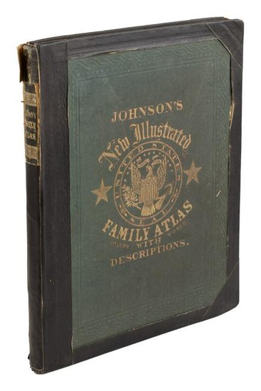
Johnson's Civil War era Family Atlas, 1863
Heading: (Maps & Atlases)
Author: Johnson, A.J.
Title: Johnson's New Illustrated (Steel Plate) Family Atlas, With Physical Geography, and with Descriptions Geographical, Statistical, and Historical, Including the Latest Federal Census, a Geographical Index, and a Chronological History of the Civil War in America.
Place Published: New York
Publisher:Johnson & Ward
Date Published: 1863
Description:
Additional engraved title page, and hand-colored lithographed maps throughout. 46x36 cm (18x14¼"), original morocco-backed cloth, front cover lettered in gilt.
Complete Johnson's atlas produced in the Civil War year of 1863, with a "New Military Map of the United States Showing the Forts, Military Posts, &c., with Enlarged Plans of Southern Harbors," and "Map of the Vicinity of Richmond, and Peninsular Campaign in Virginia," as well as the various states and nations of the World. Includes a double-page map od Texas, and other significant maps of the western portion of the United States. The maps are numbered 1-99, but many maps are double-page so take up two numbers, and in a few instances there are more than one map per sheet. Phillips Atlases 840.Lots sold without reserve are sold "as is" and are not returnable under any circumstances. The minimum shipping and handling per invoice is $25 for shipments to the US and $40 for shipments sent outside the US Please consider this when determining your bid amounts
Condition Report: Rather crude cloth tape repairs to spine, joints, edges and hinges, and to versos of a few of the maps; light stains to a few top margins; very good internally, most maps quite clean.
View it on
Sale price
Estimate
Time, Location
Auction House
Heading: (Maps & Atlases)
Author: Johnson, A.J.
Title: Johnson's New Illustrated (Steel Plate) Family Atlas, With Physical Geography, and with Descriptions Geographical, Statistical, and Historical, Including the Latest Federal Census, a Geographical Index, and a Chronological History of the Civil War in America.
Place Published: New York
Publisher:Johnson & Ward
Date Published: 1863
Description:
Additional engraved title page, and hand-colored lithographed maps throughout. 46x36 cm (18x14¼"), original morocco-backed cloth, front cover lettered in gilt.
Complete Johnson's atlas produced in the Civil War year of 1863, with a "New Military Map of the United States Showing the Forts, Military Posts, &c., with Enlarged Plans of Southern Harbors," and "Map of the Vicinity of Richmond, and Peninsular Campaign in Virginia," as well as the various states and nations of the World. Includes a double-page map od Texas, and other significant maps of the western portion of the United States. The maps are numbered 1-99, but many maps are double-page so take up two numbers, and in a few instances there are more than one map per sheet. Phillips Atlases 840.Lots sold without reserve are sold "as is" and are not returnable under any circumstances. The minimum shipping and handling per invoice is $25 for shipments to the US and $40 for shipments sent outside the US Please consider this when determining your bid amounts
Condition Report: Rather crude cloth tape repairs to spine, joints, edges and hinges, and to versos of a few of the maps; light stains to a few top margins; very good internally, most maps quite clean.


