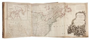
* KITCHIN, Thomas (1718-1784). A General Atlas, Describing the Whole Universe. London: Robert Laurie and James Whittle, 1795.
Folio (530 x 370 mm). 25 engraved maps on 37 double-page and folding sheets, all hand-colored in outline. (A few maps with edges slightly fraying, a few short tears to folds or margins, occasionally with repairs, some light offsetting.) Contemporary half calf, marbled boards (some wear, joints starting).
A later edition of Kitchin's popular atlas, first conceived by Thomas Jefferys in the 1760s, and completed by his successor Robert Sayer and first published in 1773. It was subsequently published by Sayer and his heirs, Laurie and Whittle, almost annually. Phillips 3529 (with map of Europe dated 1794, but here dated 1795; with map of Spain dated 1790, but here dated 1794). [Bound in:] Four additional maps, comprising: DUNN, Samuel. A New Chart of the World on Mercator's Projection. London: Laurie & Whittle, 12 May 1794. -- A Chart of the Island of Hispaniola. -- Martinico From the best Authorities. From "The New Jamaica Almanac." 1798. -- Cuba, with the Bahama Islands and Gulf of Florida.
View it on
Sale price
Estimate
Time, Location
Auction House
Folio (530 x 370 mm). 25 engraved maps on 37 double-page and folding sheets, all hand-colored in outline. (A few maps with edges slightly fraying, a few short tears to folds or margins, occasionally with repairs, some light offsetting.) Contemporary half calf, marbled boards (some wear, joints starting).
A later edition of Kitchin's popular atlas, first conceived by Thomas Jefferys in the 1760s, and completed by his successor Robert Sayer and first published in 1773. It was subsequently published by Sayer and his heirs, Laurie and Whittle, almost annually. Phillips 3529 (with map of Europe dated 1794, but here dated 1795; with map of Spain dated 1790, but here dated 1794). [Bound in:] Four additional maps, comprising: DUNN, Samuel. A New Chart of the World on Mercator's Projection. London: Laurie & Whittle, 12 May 1794. -- A Chart of the Island of Hispaniola. -- Martinico From the best Authorities. From "The New Jamaica Almanac." 1798. -- Cuba, with the Bahama Islands and Gulf of Florida.


