MAP, US, World War II, Turner
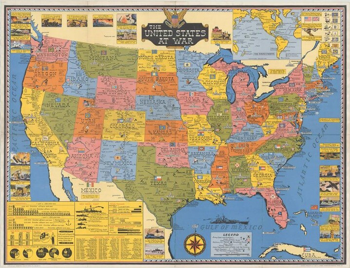
United States, World War II. Stanley Turner, The United States at War, 1943 (dated). Printed Color. This pictorial propaganda map depicts United States' prosperity and ability to support the Allies during World War II. Each state includes information and pictograms on the natural resources and manufacturing capabilities that could be used in the war effort, as well as basic details about the state, such as population, size in square miles, the state flag and flower, and key cities. The locations of military camps are marked with tiny American flags and military air fields are marked with tiny biplanes. Surrounding the map are numerous small vignettes representing important events during the war, including the signing of the Atlantic Charter, the dates of various U.S. troop landings in Europe and Africa, and the attack on Pearl Harbor. At bottom left are pictographs illustrating the United States' military strength in terms of army and navy personnel, war bonds, manufacturing output, the size of the naval fleet, and more. On verso is a black and white map depicting the seat of war in the eastern hemisphere.
The map was created by Stanley Turner and published by C. C. Petersen in Toronto. Turner (1883-1953) was born in England and emigrated to Canada as a young adult. He studied art at the Ontario College of Art in Toronto and is known for his ability to work in many different types of media. During World War II, Turner worked for Canadian newspaper "The Globe and Mail" to design war-related maps.
Dimensions: 19.7 x 25.9 in
Condition Report: A clean and bright example, issued folding and now flattened and professionally backed in thin, archival tissue to repair some separations along the folds and small holes at fold intersections. Grade: A
View it on
Estimate
Time, Location
Auction House
United States, World War II. Stanley Turner, The United States at War, 1943 (dated). Printed Color. This pictorial propaganda map depicts United States' prosperity and ability to support the Allies during World War II. Each state includes information and pictograms on the natural resources and manufacturing capabilities that could be used in the war effort, as well as basic details about the state, such as population, size in square miles, the state flag and flower, and key cities. The locations of military camps are marked with tiny American flags and military air fields are marked with tiny biplanes. Surrounding the map are numerous small vignettes representing important events during the war, including the signing of the Atlantic Charter, the dates of various U.S. troop landings in Europe and Africa, and the attack on Pearl Harbor. At bottom left are pictographs illustrating the United States' military strength in terms of army and navy personnel, war bonds, manufacturing output, the size of the naval fleet, and more. On verso is a black and white map depicting the seat of war in the eastern hemisphere.
The map was created by Stanley Turner and published by C. C. Petersen in Toronto. Turner (1883-1953) was born in England and emigrated to Canada as a young adult. He studied art at the Ontario College of Art in Toronto and is known for his ability to work in many different types of media. During World War II, Turner worked for Canadian newspaper "The Globe and Mail" to design war-related maps.
Dimensions: 19.7 x 25.9 in
Condition Report: A clean and bright example, issued folding and now flattened and professionally backed in thin, archival tissue to repair some separations along the folds and small holes at fold intersections. Grade: A
