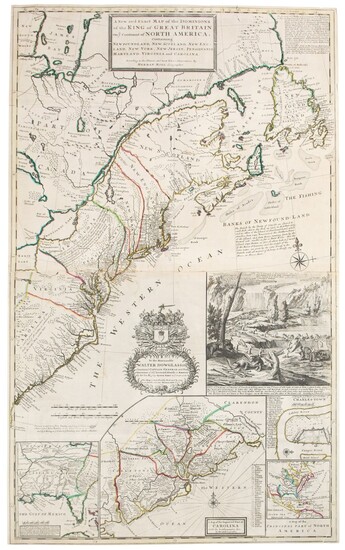
Moll, Herman | The famed "Beaver Map"
Moll, Herman
A New and Exact Map of the Dominions of the King of Great Britain on ye continent of North America containing Newfoundland, New Scotland, New England, New York, New Jersey, Pensilvania [sic.] Maryland, Virginia and Carolina. According to the newest and most exact observations. London: Printed and Sold by Tho: Bowles next ye Chapter House in St. Pauls Church-yard, John Bowles, at the Black Horse in Cornhill and by I. King at ye Globe in ye Poultrey [sic.] near Stocks Market, [1731]
Copper-engraved map on two joined sheets (overall if joined: 1,022 x 629 mm). Period hand-color in outline, state four or five; tears to fold expertly repaired.
The famous "Beaver Map" of the English and French colonies in North America
"One of the first and most important cartographic documents relating to the ongoing dispute between France and Great Britain over boundaries separating their respective American colonies...The map was the primary exponent of the British position during the period immediately following the Treaty of Utrecht in 1713" (Degrees of Latitude). The British colonies according to British claims are outlined in red, with the French very lightly outlined in blue. All territory south of the St. Lawrence River and eastern Great Lakes is shown as British. Numerous notations relating to territorial claims, Indian tribes, the fur trade, and the condition of the land cover the face of the map. This map shows the early eighteenth century postal routes in the British colonies, and is frequently called the first American postal map.
There are four insets, including a large map of coastal South Carolina, and a plan of Charleston. At lower left is a map of Florida and the Deep South, which is based on a map by Thomas Nairne, the Indian agent for South Carolina. The most striking feature is the large vignette which gives the map it's popular name. It consists of an early view of Niagara Falls, with a colony of beavers at work in the foreground. Pritchard holds that the beaver "was an appropriate image for the North American map for two reasons: the animal's importance to the fur trade, and its industrious nature."
REFERENCE
Cumming, British Maps 6-12; Cumming, Southeast in Early Maps 158; Degrees of Latitude 19 (state 4); Reinhartz, Herman Moll Geographer 18-36; Schwartz and Ehrenberg, Mapping of America 138, 144; Stevens and Tree, "Comparative Cartography," 55 (c), in Tooley Mapping of America
Condition Report:
Condition as described in catalogue entry.
View it on
Sale price
Estimate
Time, Location
Auction House
Moll, Herman
A New and Exact Map of the Dominions of the King of Great Britain on ye continent of North America containing Newfoundland, New Scotland, New England, New York, New Jersey, Pensilvania [sic.] Maryland, Virginia and Carolina. According to the newest and most exact observations. London: Printed and Sold by Tho: Bowles next ye Chapter House in St. Pauls Church-yard, John Bowles, at the Black Horse in Cornhill and by I. King at ye Globe in ye Poultrey [sic.] near Stocks Market, [1731]
Copper-engraved map on two joined sheets (overall if joined: 1,022 x 629 mm). Period hand-color in outline, state four or five; tears to fold expertly repaired.
The famous "Beaver Map" of the English and French colonies in North America
"One of the first and most important cartographic documents relating to the ongoing dispute between France and Great Britain over boundaries separating their respective American colonies...The map was the primary exponent of the British position during the period immediately following the Treaty of Utrecht in 1713" (Degrees of Latitude). The British colonies according to British claims are outlined in red, with the French very lightly outlined in blue. All territory south of the St. Lawrence River and eastern Great Lakes is shown as British. Numerous notations relating to territorial claims, Indian tribes, the fur trade, and the condition of the land cover the face of the map. This map shows the early eighteenth century postal routes in the British colonies, and is frequently called the first American postal map.
There are four insets, including a large map of coastal South Carolina, and a plan of Charleston. At lower left is a map of Florida and the Deep South, which is based on a map by Thomas Nairne, the Indian agent for South Carolina. The most striking feature is the large vignette which gives the map it's popular name. It consists of an early view of Niagara Falls, with a colony of beavers at work in the foreground. Pritchard holds that the beaver "was an appropriate image for the North American map for two reasons: the animal's importance to the fur trade, and its industrious nature."
REFERENCE
Cumming, British Maps 6-12; Cumming, Southeast in Early Maps 158; Degrees of Latitude 19 (state 4); Reinhartz, Herman Moll Geographer 18-36; Schwartz and Ehrenberg, Mapping of America 138, 144; Stevens and Tree, "Comparative Cartography," 55 (c), in Tooley Mapping of America
Condition Report:
Condition as described in catalogue entry.


