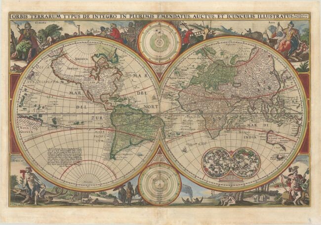
"Orbis Terrarum Typus de Integro in Plurimis Emendatus, Auctus, et Icunculis Illustratus", Visscher, Nicolas
Subject: World
Period: 1657 (circa)
Color: Hand Color
Size: 12.1 x 18.8
An exquisitely decorated double hemisphere world map, surrounded by engravings including allegorical representations of the continents as well as native inhabitants and wildlife. This is Visscher's first world map to be included in Dutch Bibles. It was so popular that the surrounding decorations were copied by several other cartographers. Two celestial spheres are displayed in the Eastern Hemisphere. In the lower part of the Western Hemisphere text describes the discovery of America and recent voyages of discovery. Two diagrams depicting the Ptolemaic and Copernican theories of the solar system are tucked between the hemispheres. The northwest coast of North America is exaggerated and shows California correctly as a peninsula. Parts of Australia and Van Diemen's Land are shown, but the north and east coasts of Australia are not depicted. Dutch text on verso.See also lot 848 for Rodney Shirley's The Mapping of the World - Early Printed World Maps 1472-1700 that describes this map.
References: Poortman & Augusteijn #83; Shirley #401.
Condition: B+
A rare example in full contemporary color that has been partially refreshed, on a sheet with a Strasburg Lily watermark. There is light toning along the centerfold and professional repairs to some tiny tears along the centerfold and in the bottom margin.
View it on
Sale price
Estimate
Time, Location
Auction House
Subject: World
Period: 1657 (circa)
Color: Hand Color
Size: 12.1 x 18.8
An exquisitely decorated double hemisphere world map, surrounded by engravings including allegorical representations of the continents as well as native inhabitants and wildlife. This is Visscher's first world map to be included in Dutch Bibles. It was so popular that the surrounding decorations were copied by several other cartographers. Two celestial spheres are displayed in the Eastern Hemisphere. In the lower part of the Western Hemisphere text describes the discovery of America and recent voyages of discovery. Two diagrams depicting the Ptolemaic and Copernican theories of the solar system are tucked between the hemispheres. The northwest coast of North America is exaggerated and shows California correctly as a peninsula. Parts of Australia and Van Diemen's Land are shown, but the north and east coasts of Australia are not depicted. Dutch text on verso.See also lot 848 for Rodney Shirley's The Mapping of the World - Early Printed World Maps 1472-1700 that describes this map.
References: Poortman & Augusteijn #83; Shirley #401.
Condition: B+
A rare example in full contemporary color that has been partially refreshed, on a sheet with a Strasburg Lily watermark. There is light toning along the centerfold and professional repairs to some tiny tears along the centerfold and in the bottom margin.


