Survey of the World
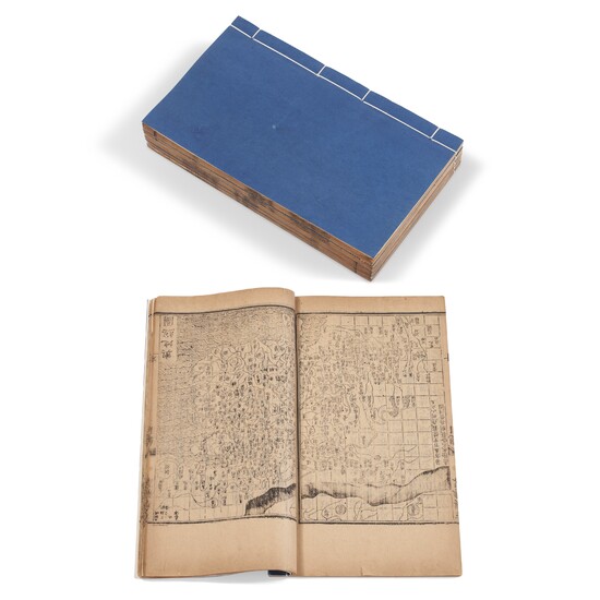
CHENG, Youyu (1573-1629). Fangyu Shenglue [Complete Survey of the World]. China, Wanli period, 1610.
Early edition of a rare Chinese geography. This compilation was first made during the Ming dynasty by Cheng Youyu (or Cheng Bai’er, 1573-1629). The set of six volumes includes maps of China and its provinces in the Ming dynasty. It was much in demand, and was reprinted many times. It contains a mass of historical and geographical information, including place names, local agricultural practices and produce, details of the local nobility, location of important gates and temples as well as graveyards.
18 volumes bound in 6 (270 x 165 mm). Woodblock printed on double leaves in the manner of the period. Illustrated with maps. Later Chinese blue paper wrappers, no title slips. (Sides slightly chipping, paper inside lightly toned; book one with dampstaining, wormholes, surface abrasions, splitting of some double leaves, leading to some loss of text; book two with slight marginal tears; book three with dampstains and double-leaf splitting on the first few pages; book five and six with a few wormholes).
Please note that this lot is subject to an import tariff. If the buyer instructs Christie’s to arrange shipping of the lot to a foreign address, the buyer will not be required to pay the import tariff. If the buyer instructs Christie’s to arrange shipping of the lot to a domestic address, if the buyer collects the property in person, or if the buyer arranges their own shipping (whether domestically or internationally), the buyer will be required to pay the import tariff. Please contact Post Sale Services on +1 212 636 2650 prior to bidding for more information.
View it on
Sale price
Estimate
Time, Location
Auction House
CHENG, Youyu (1573-1629). Fangyu Shenglue [Complete Survey of the World]. China, Wanli period, 1610.
Early edition of a rare Chinese geography. This compilation was first made during the Ming dynasty by Cheng Youyu (or Cheng Bai’er, 1573-1629). The set of six volumes includes maps of China and its provinces in the Ming dynasty. It was much in demand, and was reprinted many times. It contains a mass of historical and geographical information, including place names, local agricultural practices and produce, details of the local nobility, location of important gates and temples as well as graveyards.
18 volumes bound in 6 (270 x 165 mm). Woodblock printed on double leaves in the manner of the period. Illustrated with maps. Later Chinese blue paper wrappers, no title slips. (Sides slightly chipping, paper inside lightly toned; book one with dampstaining, wormholes, surface abrasions, splitting of some double leaves, leading to some loss of text; book two with slight marginal tears; book three with dampstains and double-leaf splitting on the first few pages; book five and six with a few wormholes).
Please note that this lot is subject to an import tariff. If the buyer instructs Christie’s to arrange shipping of the lot to a foreign address, the buyer will not be required to pay the import tariff. If the buyer instructs Christie’s to arrange shipping of the lot to a domestic address, if the buyer collects the property in person, or if the buyer arranges their own shipping (whether domestically or internationally), the buyer will be required to pay the import tariff. Please contact Post Sale Services on +1 212 636 2650 prior to bidding for more information.


