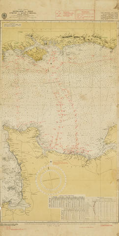
WORLD WAR II, D-DAY: CHART OF THE ENGLISH CHANNEL MARKING THE MINE SWEPT SEA CHANNELS to THE BEACHES OF NORMANDY.
Englsh Channel Eastbourne to Poole. Etretat to Mont St Michel. London: Hydrographic Office, 24th March 1944 (3rd edition, 7 July 1944).
Englsh Channel Eastbourne to Poole. Etretat to Mont St Michel. London: Hydrographic Office, 24th March 1944 (3rd edition, 7 July 1944).
Photo lithographic Admiralty chart in 3 colors, of the central part of the English Channel, with a red military overprint, the chart marked Confidential. 33 x 17 inches (850 x 425 mm). Occasional light spotting. Mount board, framed and glazed.
A secret chart, presumably issued to captains and pilots for the passage across the channel, from June 6th to mid August, as the Normandy beach heads expanded to receive the millions of tons of supplies and thousands of troops that were funnelled into Normandy after D-Day. The chart shows the point of ship congregation "Z Area," south east of the Isle of Wight, and the two principal channels (mine cleared), stretching across the channel and then diverging to each of the beach heads at Utah, Omaha, Juno, Sword and Gold. (presumably also cleared of mines).
View it on
Sale price
Estimate
Time, Location
Auction House
Englsh Channel Eastbourne to Poole. Etretat to Mont St Michel. London: Hydrographic Office, 24th March 1944 (3rd edition, 7 July 1944).
Englsh Channel Eastbourne to Poole. Etretat to Mont St Michel. London: Hydrographic Office, 24th March 1944 (3rd edition, 7 July 1944).
Photo lithographic Admiralty chart in 3 colors, of the central part of the English Channel, with a red military overprint, the chart marked Confidential. 33 x 17 inches (850 x 425 mm). Occasional light spotting. Mount board, framed and glazed.
A secret chart, presumably issued to captains and pilots for the passage across the channel, from June 6th to mid August, as the Normandy beach heads expanded to receive the millions of tons of supplies and thousands of troops that were funnelled into Normandy after D-Day. The chart shows the point of ship congregation "Z Area," south east of the Isle of Wight, and the two principal channels (mine cleared), stretching across the channel and then diverging to each of the beach heads at Utah, Omaha, Juno, Sword and Gold. (presumably also cleared of mines).


