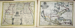
Wells 1701 World Atlas
Wells, Edward (1667-1727). A new Sett of Maps both of the Antient and Present Geography. Oxford: Printed at the Theatre, 1701.
Folio (16 4/8 x 23 inches). Letterpress title and index printed in black. 41 double-page engraved maps by M. Burghers, B. Cole, J. Moxon, Ed. Smith, R. Spofforth and Sutton Nicholls, bound to face each other, and all with original hand-colour in full (one or two marginal tears just entering the neat line, some light marginal staining). Later half calf over original marbled paper boards (worn, endpapers creased and with short tears). First published in 1700. Including two double-hemisphere world maps, maps of North and South America, and the “English Plantations in Americaâ€. In addition to a number of religious polemics, Wells published a series of descriptive geographies, “largely cribbed from other sources, but widely recommended at schools and universities in the period. His ‘Treatise of Antient and Present Geography’ (1701; and four further editions) was a popular gazetteer intended for students reading classics, while his ‘Historical Geography of the New Testamen’t (1708) and the companion ‘Historical Geography of the Old Testamen’t (1711–12) plagiarized travellers to the Near East and biblical scholars to give a description of the Holy Land, but also attacked Roman Catholicism and Presbyterianism in passing†(Robert J. Mayhew for DNB). The maps in this atlas are poignantly dedicated to the young Prince William, Duke of Gloucester who, disabled all his short life, died in 1700 of suspected small pox. The plates were prepared by some of the most accomplished engravers in Oxford including Michael Burghers, who worked for Moses Pitt on his atlas. First edition: Phillips, Atlases 3489; Shirley, British Library T.WELL-1a.
Comparable: Old World Auctions, 2/20/08 - $12,320.
View it on
Sale price
Estimate
Reserve
Time, Location
Auction House
Wells, Edward (1667-1727). A new Sett of Maps both of the Antient and Present Geography. Oxford: Printed at the Theatre, 1701.
Folio (16 4/8 x 23 inches). Letterpress title and index printed in black. 41 double-page engraved maps by M. Burghers, B. Cole, J. Moxon, Ed. Smith, R. Spofforth and Sutton Nicholls, bound to face each other, and all with original hand-colour in full (one or two marginal tears just entering the neat line, some light marginal staining). Later half calf over original marbled paper boards (worn, endpapers creased and with short tears). First published in 1700. Including two double-hemisphere world maps, maps of North and South America, and the “English Plantations in Americaâ€. In addition to a number of religious polemics, Wells published a series of descriptive geographies, “largely cribbed from other sources, but widely recommended at schools and universities in the period. His ‘Treatise of Antient and Present Geography’ (1701; and four further editions) was a popular gazetteer intended for students reading classics, while his ‘Historical Geography of the New Testamen’t (1708) and the companion ‘Historical Geography of the Old Testamen’t (1711–12) plagiarized travellers to the Near East and biblical scholars to give a description of the Holy Land, but also attacked Roman Catholicism and Presbyterianism in passing†(Robert J. Mayhew for DNB). The maps in this atlas are poignantly dedicated to the young Prince William, Duke of Gloucester who, disabled all his short life, died in 1700 of suspected small pox. The plates were prepared by some of the most accomplished engravers in Oxford including Michael Burghers, who worked for Moses Pitt on his atlas. First edition: Phillips, Atlases 3489; Shirley, British Library T.WELL-1a.
Comparable: Old World Auctions, 2/20/08 - $12,320.


